Lots of south swell for Northern NSW, then an E/NE swell for SE Qld

South-east Queensland and Northern NSW Surf Forecast by Ben Matson (issued Monday 14th October)
Best Days: Tues: building south swell across Northern NSW. Wed/Thurs/Fri: solid fluctuating south swell across Northern NSW, possibly some small waves in SE Qld late Thurs/Fri. Sat/Sun: small trade swell for SE Qld. Mon/Tues/Wed/Thurs: building E/NE swell, biggest in SE Qld.
Recap: Very small surf persisted over the weekend with mainly N’ly winds across most coasts. Similar conditions have held out into today.
This week (Nov 15th - 18th)
There’s a fair push of south swell on the way and we’re looking at a few days of very good waves across Northern NSW. SE Qld surfers won’t see much from this source unfortunately, but there are good long term prospects starting to firm up.. read more below.
Back to this week, and we’ve got two separate south swells on the way for this week.
Right now a Tasman low is driving a cold front across the Southern NSW coast, and strong to gale force S’ly winds in its wake will whip up large southerly swells that will build through Tuesday, before easing back on Wednesday.
South facing beaches south of Byron should see a peak somewhere in the 4-6ft range throughout the day - mid-late morning south of Coffs, and mid-late afternoon north of Coffs - though the acute swell direction will create smaller waves at beaches with less southern exposure. The later building trend across the Far North also means it’ll start from a smaller base so keep your size expectations in check here if you’re planning on an early surf.
Winds are looking to be moderate to fresh S/SW for the most part, with a chance for early SW winds in some regions, so open beaches will become blown out and the best waves will be found at semi-exposed points.
North of Byron, we’ll see smaller surf across the Tweed Coast (with a very late peak in size, so don’t be surprised if the morning is quite small) and it’ll be very small throughout SE Qld, only favouring south swell magnets with some stray 2ft+ sets on dark and tiny waves persisting across the remaining beaches and points.
This southerly swell will level out into Wednesday across the Far North/SE Qld coasts, but ease across the Mid North Coast.
In fact, there are two feeder sources of swell that will supply good background swell through Wednesday and early Thursday across Northern NSW. The first is a developing E/SE through SE then S’ly fetch at the bottom flank of the low - immediately west of the SW tip of New Zealand’s South Island today.
Secondly, despite the Tasman low moving eastwards, a ridge will remain across the SE Tasman Sea on Tuesday with strong SW winds exiting eastern Bass Strait, which will continue to generate smaller sideband energy through the middle of the week in the 3ft+ range for south facing beaches.
Additionally, conditions are looking good on Wednesday with light winds and sea breezes.
A second cold front currently developing SW of Tasmania today is then expected to enter the Lower Tasman Sea later Tuesday, eventually merging with the remnants of the current Tasman Low by early Wednesday. This progression will result in gale force S’ly winds through the lower Tasman Sea that will kick up a renewal of solid south swell for Thursday morning across the Mid North Coast, and Thursday afternoon across the Far North Coast.
Whilst less favourably aligned for the East Coast (partly due to the fetch orientation, and partly due to the more eastern position of the fetch), the groundswell generated should be very good quality - even if it only glances the coast.
As such I think we’ll probably see a similar size range as per late Tuesday, if not a smidge higher across the northern parts of the NSW coast, with sets around the 4-6ft mark at most south facing beaches. Otherwise, once again expect smaller surf at beaches not completely open to the south.
SE Qld should see a little more size from this swell too, but only just - up to 3ft+ at reliable south swell magnets north of the border late in the day, and 1-2ft+ across most open beaches and outer points (again, much smaller in the morning). However set waves will be very inconsistent.
The only concern we have on Thursday is a freshening SE breeze across Northern NSW and SE Qld as a ridge develops through the Coral Sea. We may see an early period of SE winds in some regions but for the most part the SE flow will extend down to about Yamba (light variable winds and sea breezes are expected across the Mid North Coast).
As for Friday, we’ll see slowly easing S/SE swell from Thursday afternoon across Northern NSW, with a supplementary SE swell across SE Qld beaches (~2ft or so). Because the swell will be drying up from the south, we’ll see smaller surf across the Mid North Coast (3-4ft) than the Far North Coast (4-5ft), but conditions should be generally favourable south of Byron with light winds and sea breezes. Far Northern NSW and SE Qld may see a lingering E/SE flow but pockets of SW wind are possible early.
This weekend (Nov 19th - 20th)
There’s no amazing surf expected across any coast this weekend, however given the extended period of poor surf experienced in SE Qld, comparatively speaking we should see some super fun beachies across the Gold, Sunshine and Tweed Coasts.
First up - the southerly swells from later this week will ease rapidly by Saturday so expect only small residual energy from these sources.
Otherwise, an anchoring ridge through the Coral Sea should generate some peaky E’ly trade swell for the Far Northern NSW and SE Qld coasts, biggest on the Sunshine Coast and smaller with increasing southerly latitude. Surf size will build slowly through Saturday, and Sunday should offer 2-3ft waves across most beaches, with a few bigger sets across the Sunshine Coast.
Winds look to be mainly onshore this weekend though not very strong,and we should see periods of light variable winds in the early mornings.
South of Byron, this east swell won’t show up very much and winds will freshen from the north, creating below average conditions. However, Sunday is also on target to see a very small but long period southerly groundswell across Northern NSW, originating from a deep mid-latitude low tracking well below Tasmania later this week.
It’s not very well aligned for our coast but the sheer size and strength of the low (50kt+ surface winds) should override some of the directional deficiencies. As such south facing beaches could be looking at very inconsistent 3ft+ sets at times, more likely through the afternoon than the morning. I’ll update this in more detail on Wednesday.
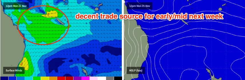
Next week (Nov 21st onwards)
In Friday’s notes I mentioned a modelled tropical system at the back end of the run, which I didn’t think stood much of a chance of developing into anything noteworthy.
Well, it looks like I was wrong. This system still showing in the long term forecast (though the models have been shunting it slowly backwards in time), and we are potentially looking towards a sustained period of small to medium sized E/NE swell from this region thanks to a regional blocking pattern keeping this system anchored in the Coral Sea.
It’s too early to look at specifics - and there is also a risk that this period will be accompanied by a lengthy period of E/NE thru NE and N/NE wind - but we’re on track we can expect a slowly building E/NE swell from Monday through Wednesday and maybe even Thursday, that could reach 4-5ft at exposed beaches (biggest across SE Qld, smaller as you track south of Byron).
Keeping in mind that this is still more than a week away, we’ll watch closely over the updated model runs over the coming days.
Comments
That'll do
Thanks as always Ben. I especially like it when you bring good news.
Sweet
nothing beats a peaky trade swell. I love those days where it's super consistent and you find a beachy with just you and your mates, I hope the winds don't spoil the party
Looking good after such a horrible couple of months in SE Qld. Great insight and analysis as always
I can only imagine that the crew will be out in full force, but gosh who cares. Finally some waves !
No shortage of south swell in Coffs this morning.
Its Building quickly around Coffs coast
i dont think i have ever seen the Pass so mirror flat.
FROTH!!!!
this morning was tiny but greats for kids at coolum.
the froth is for the next week.
weird that i can see the pics ben shares on my phone but not on the computer
Gday skatement, way off topic, but do You get Your blanks machine cut local on Sunny Coast? Care to give any details? Wish I was gunna be home for this swell!
Dunno about 4 to 5 foot...... I'm still sticking with my 3 foot call.
Models had 3-5ft yesterday, but have upgraded overnight - now calling 8ft (!) out of the E/NE for Tuesday.
That ridge keeps getting more colourful.
8ft NE swell and an SE wind?! I reckon I know where I'm heading! :D
If you leave now you might just get a park.
Haha, scored me a fair few the last time it turned on :)
Don't forget the torch
8' seems exuberant, but certainly an interesting ridge for the qld'ers to look at. Closer to sheepies call, probably a bit more, but I think donw calls them devil winds to accompany. Good luck gentlemen.
fair bit of variation in the models......and a helluva lot depends on the movement and strength of any developing low/trough.
nice looking pattern though....it'll be nice whether it's 2-3ft or 8ft(strongly doubt). Lets hope this is the pattern-changer we need.
Last I looked (this morning's runs only) GFS was by far the outlier (and over-optimistic in surf height) compared with Access G and EC. Local winds more favourable based on GFS also given it has the axis of the trough/low inside New Cal and sliding south, whilst this morning Access G and EC had the low staying up north, which means less swell and potentially more onshore (E/SE) winds. But hey, it's certainly worthy of keeping an eye on as there's nothing else to look at. Impressed to see this so early in the season too.
Making this coast great again? pmsl
8 foot........ Yeah..... ok..... lol
agree Don, GFS is by far the most optimistic.
Great to see the regular suspects back. hoping for a great season for us.
With sheepster with the onshore's
But who cares !!
How do you guys in Gold Coast and sunshine cope with months of Shit surf with the odd good session. Sure you get your good cyclone swells but are they worth it when in the other half of the year your just faced with weeks of 1-2ft onshore waves. And when it does turn on most of the waves are packed bloody hell move down the coast to Byron bay oh shit there's a shit tonnes of sharks its loose loose for you blokes hope you guys are doing alright.
Why is a Victorian surfer on a SE Qld/Nth NSW Forecast page attempting to stir shit?
Rhetorical question clearly
Because everyone in Victoria can't stand him!
Haha love it goofy back to Mornington mate, to be honest it's not much better than Gold Coast at the moment, but don't worry you're used to closeouts hope your having a good day
Us in Vicco are coping 5 days of onshores winds it just made me reflect on the states who are doing it even more tough. I mean for the last 4 months we have had waves in the 3-6ft range with mostly offshores while you guys have got nothing
We spend our time on intellectual pursuits, honing our written discourse and punctuation. I suggest you do the same, instead of your 5 day binge molestation of local livestock.
Love the aggression waxy, don't worry you will get some waves soon, it's not your fault that you were brought up where are waves are sloppy for months on end. What do you do in your spare time you would have been able to to fix up the house, do some extra work in the garden. I do rate the weather though up in Queensland it's very nice
I wasn't brought up in those conditions, but more than happy here nonetheless ;)
That's lucky, nice :)
Well ECs certainly upped the anti this morning.
Nice to see our Sunshine Beach cam showing small lines of south swell.

Yeah, surfed nearby early this morning and bomb sets were 3ft+. Not much shape but there was swell.
pretty lacklustre and weak first pulse of S swell yesterday and today. it tried but nothing really happened.
Before the tide killed the swell.
The current sand out off dbah has killed that place at any real tide and swell.