Fun easterly swells for the short term; dynamic systems on the boil following Xmas

South East Queensland and Northern New South Wales Surf Forecast by Ben Matson (issued Friday 18th December)
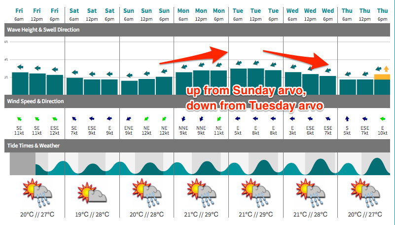
Best Days: Sat: early peaky beachies. Sun: building E'ly swell in the arvo, keep an eye out for a LAGOS (apart from Mid North Coast). Mon/Tues: quality trade swell, biggest in SE Qld with light morning winds. Wed: easing E'ly swell, plus a S'ly groundswell and short range SE swell for Northern NSW.
Recap: Building E’ly swell trough Thursday that’s held into today with 2-3ft sets across the Gold Coast and Far Northern NSW coast, with slightly bigger surf on the Sunshine Coast but smaller surf south of Yamba. Mainly early light winds tending onshore. Fun waves around in general but nothing overly amazing.
This weekend (Saturday 19th - Sunday 20th December)
Now that we’re on the cusp of the weekend we can take a closer look at the specific swell trends for the next two days.
The east swell present in the water today isn’t very strong, and its source is slowly contracting northwards into the Coral Sea, outside of our swell window. This means we can expect a slow easing trend all weekend from now through until about Sunday morning, when the next upwards phase of energy is expected to start filling in.
Being on the backside of this swell event, and with the swell source not perfectly aimed our way, Saturday’s waves will also be quite tidally dependent, and rather inconsistent too. We can expect a similar spread of size as per today, with the biggest waves on the Sunshine Coast (2-3ft), and smaller surf as you progress down along the Gold and Tweed Coasts (2ft+), with smaller 2ft surf through to Yamba and 1-2ft surf along the Mid North Coast.
Make the most of the early light winds as afternoon sea breezes will bump up conditions after lunch. Expect surf size to decrease all day and become much weaker through the afternoon, especially with the high tide.
On Sunday, we’ll be starting from a small, slow and inconsistent base (1-2ft open beaches, smaller south of Ballina) but the good news is that surf size will rebuild during the day.
The source of this upwards trend is a broader secondary fetch expected to develop in and around the New Caledonian region on Saturday, and by the end of the day we should see some healthy trade swell across the region - but once again with the biggest surf in the north (i.e. 2-3ft Sunshine Coast, maybe some bigger bombs on dusk), and smaller surf south from the Gold and Tweed Coasts (2ft, maybe 2-3ft by the end of the day) down to the Mid North Coast (late 2ft sets).
Similar winds are expected as per Saturday (early light offshore, with sea breezes developing from mid-late morning onwards) so it’s a shame that the afternoon’s increase will probably be quite bumpy. But don’t rule out a late afternoon glass-off either - it’s happened a few times across a few regions in recent weeks and it’s usually these sessions that are the least crowded too.
The only area unlikely to see the possibility of a late afternoon glass off is the Mid North Coast, as we’re looking at a strengthening NE gradient wind on Sunday that’ll also whip up some local windswell after lunch. But otherwise you’ll have to head into a sheltered northern corner for the best conditions.
Next week (December 21st onwards)
Sunday’s building E’ly swell is expected to peak on Monday, possibly even holding into Tuesday morning. I’ve pulled back my size estimates a touch since Wednesday’s notes, but the general principle remains the same - biggest on the Sunshine Coast (3-4ft), with smaller 3ft+ sets across the Gold and Tweed Coasts and 2-3ft surf down to about Coffs and maybe even Port Macquarie if you like.
The difference between this swell and the current trade swell is the source and direction - the fetch is located further north, and is aimed more E/NE if anything so we should see a broader southward spread. The Mid North Coast may also see some local windswell loading from gusty NE winds expected later Sunday; they’ll continue through Monday though we may see early N/NW winds open up a few more locations.
Everywhere else, Monday’s winds should be early light and variable tending moderate easterly throughout the day.
From Tuesday - probably lunchtime or thereabouts - we should start to see a slow easing trend in the size department from this east swell, but the morning should display a similar level of size as per Monday. If anything, local winds are looking the pick of the forecast period on Tuesday thanks to a northward advancing low pressure trough along the Southern NSW coast on Monday, which is expected to stall just south of Port Macquarie. This should result in a weak pressure gradient for Tuesday and subsequently slack winds and maybe an afternoon sea breeze.
Wednesday is looking at a further slow easing of easterly swell - still plenty of peaky options for the open beaches, mind - but with a secondary southerly groundswell pushing across the Mid North Coast (morning) and eventually the Far North Coast (late afternoon). The source of this south swell is a deep low forming south of Tasmania over the weekend. Initially, despite its incredible strength, it’s expected to track unfavourably SE in direction, perpendicular to our swell window which greatly reduces the swell potential. But the follow up SW fetch trailing the low will be better aligned for swell potential and we should see inconsistent 3ft sets across south facing beaches at times.
Also in the mix on Wednesday - mainly in Northern NSW, specifically the Mid North Coast - will be some short range SE swell originating from a SE fetch below the stalled trough (in fact, we may even see some of this surf starting to appear late Tuesday). Wind strengths still don’t look overly great right now but either way we should see set waves somewhere in and around the 3ft mark, which should mix in nicely with the easing E’ly swell and the long range S’ly groundswell.
This trough looks like it’ll meander about the Northern NSW coast for the following few days, maintaining strength or possibly even strengthening slightly. Therefore, Xmas Eve and Xmas Day (Thurs and Fri) are looking at a slowly building short range east swell in addition to some small leftover/easing E’ly swell and inconsistent leftover/easing S’ly swell.
Now, looking much further ahead and we’ve got some potentially complex scenarios on the boil for the week following the Xmas period.
The MJO is currently approaching the Australian continent and is expected to bring a burst of monsoon activity to the Top End next week, including a possible Tropical Cyclone in the Gulf of Carpentaria.
This pattern will eventually push across Cape York Peninsula - probably some time around Boxing Day or thereabouts - which increases the probability of a cyclone in the Northern Coral Sea (though broadly speaking, the best swell generating systems in this region sometimes form a week or so in the lee of the MJO’s Coral Sea passage).
What has me most interested is the lingering coastal trough about the Northern NSW coast later next week. Moderate onshore winds are expected to extend out to about New Zealand longitudes, and this will help in dragging moisture towards the region which, combined with the approaching instability associated with the MJO and monsoon pattern, could result in a dynamic synoptic event developing within some of our short range swell windows throughout the last week of the year.
So in short - there’s an increasing chance for some sizeable waves throughout SE Qld and Northern NSW to round out 2015. Watch this space very closely.
Comments
Scored some super fun empty beachies this morning, wasn't very large, just 2ft with the odd bigger one but nice and peaky with light SW winds keeping conditions clean. Only one other surfer as far as my eyes could see too, not bad for early-mid morning Saturday!
Florence bay, Maggie Is. boxing day.or maybe even Balding Bay could be worth a shot for those desparados in Nth Qld.ha ha ha................bring it on!!!!!!!!!!
Another tidy morning of small waves, down a smidge on yesterday but still plenty of fun before the northerly kicked in. Looking forward to the coming days.
yeah two fun mornings of north coast beachies with a surprisingly small crew out round our way ( new brighton) . lottsa marine life though
Yep.Hopefully a few sneaky banks around for the morning light winds and high tide.
models are hinting at some juicy developments.
What's everyone's size prediction for xmas day Boxing Day given the latest model run for north coast nsw 3 to 5 ft ?