Meagre offerings for the coming week

Southeast Queensland and Northern New South Wales Surf Forecast by Ben Matson (issued Monday 28th June)
Best Days: Thursday: fresh NW winds and a small, directional south swell building at south swell magnets in Northern NSW, easing Friday (hardly anything in SE Qld). Later Saturday/Sunday: solid but windy S'ly swell. Should be some small waves on the points.
Recap: Wasn’t much on offer over the weekend, although as expected SE Qld (specifically the Sunshine Coast) picked up a small east swell. Monday has continued the tiny theme right across the East Coast.
This week (July 29 - Aug 1)
It’s not a good week to be refining your rail technique, big wave prowess or length-in-the-barrel skillz. Fortunately, we’ve been discussing this pattern for quite some time so it’s probably no great news to you anyway.
This spell of tiny waves is largely attributed to the Long Wave Trough, which is doing its intensification-thing south of the continent right now, and will concurrently dish out one of the biggest SA/Vicco/western Tassie swells of the year over the next four or five days (read Craig’s notes for more insight, here).
However, the storm track is a very mobile, zonal flow (west-east) and it’s also riding quite north in latitude, which ultimately means it’s positioned well and truly outside of the East Coast’s swell window.
That being said, there is a point where even poorly aligned storm tracks can produce waves for unfavourably positioned coastlines. What’s needed is an exceptionally strong, broad and lengthy duration of winds in a particular part of the swell window - and in this case it looks like we’ve got a good candidate lining up for the middle to latter part of this week. Prior to then we’re expecting tiny residual energy at best through Tuesday and Wednesday, with offshore winds keeping conditions clean.
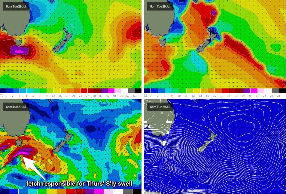
Early Wednesday morning, an intense low embedded in the storm track will pass below Tasmania, with core wind speeds likely to be in the 60kt+ range (see chart below). Whilst this will be aimed squarely away from the East Coast, the sheer size and strength of these winds - coupled in with the active sea state they’ll be working on - should allow for some spread back along the NSW coast.
The resulting long period (19-20 second) southerly swell is expected to reach the southern NSW Coast late Wednesday and should show more prominently throughout Thursday across Northern NSW, but exclusively at south facing beaches (and perhaps not quite in the water in the Far North at dawn). Very little, if any of this swell will make it ‘round the bend at Cape Byron and into SE Qld.
It’s very hard to have much confidence in the likely size range, because (a) these swell events are not very common, and (b) we’re essentially trying to refine the specifics along the outer fringes of the swell’s reach. By that, I mean that not only will there be a wide range in surf size between regular beaches and south facing beaches, but there’ll probably be a very large range in size between various south facing beaches too.
At a glance, it’s possible that a handful of south swell magnets in Northern NSW may pick up stray 2ft to perhaps 3ft sets at times, but with very long breaks between ‘em. Otherwise, expect tiny conditions to prevail. Winds will freshen from the NW, then the north so only northern corners will offer any value anyway. I'll be really interested to see what eventuates along the coast.
Thursday’s swell is expected to then ease steadily into Friday but there should still be a few small leftovers at exposed south facing beaches. Gusty NW winds are expected all day, keeping conditions clean at south facing beaches.
This weekend (Aug 2-3)
The Long Wave Trough is expected to move more to the east by the weekend, by which time its western flank should be positioned within our south swell window. This will allow a series of fronts to push up along the coast, generating short range southerly energy. At the same time we’ll also see building southerly groundswell from a series of related polar lows further south.
The upshot of this is a building weekend of southerly swell with generally fresh and gusty S’ly winds. There’s a reasonable chance for an early period of W/SW winds on Saturday morning but wave heights will be very small at this time - the biggest waves are expected from this source on Sunday (bumpy 4-6ft at south facing beaches in Northern NSW). Although exposed beaches will be quite blown out, we should still see some small clean runners across the Northern NSW points.
However SE Qld won’t fare very well from this swell - southerly winds will render the points the only workable options and they’ll probably be quite small due to the low swell period and acute southerly direction (say, somewhere around 2ft+ tops). Let’s take a closer look at the particulars on Wednesday.
Longer term (Aug 4 onwards)
A broad high pressure system developing NE of New Zealand later this week and into the weekend is expected to generate a small to moderate east swell for the first half of next week. It’ll probably slip underneath the pre-existing S’ly swell in Northern NSW, but SE Qld will enjoy this swell direction a lot more and the peaky combo of both swells should provide some good beachies. I'm not expecting much more than a couple of feet at exposed spots but there should be something to work with.
Also in the mix for much of next week will be a series of southerly groundswells in Northern NSW, courtesy of more strong fronts expected to pass south of Tasmania . More on all of these swells in Wednesday’s update.