Good weekend, large and stormy early-mid next week

South Australian Forecast by Craig Brokensha (issued Friday May 20th)
Best Days: Both coasts tomorrow (Mid Coast later), South Coast Sunday, South Coast protected spots Tuesday and Wednesday, both coasts Thursday
Features of the Forecast (tl;dr)
- Moderate + sized inconsistent W/SW-SW groundswell building tomorrow PM, peaking Sun AM, easing
- Moderate N/NE winds tomorrow, tending variable later
- Strengthening N/NE-NE tending N/NW winds Sun
- Building mix of W'ly swell and NW windswell Mon with strong N/NW winds
- Large stormy W'ly swell Tue with strong W/NW-W winds
- Large SW groundswell Wed with strong W tending W/SW winds
- Easing surf Thu with variable winds
Recap
Wednesday’s swell eased off through yesterday with clean but small 2ft sets left down South, wind affected and to 1-1.5ft across the Mid Coast.
Today, some inconsistent, long-range swell has filled in with 2ft sets across the Mid Coast with workable winds, 2ft and clean across the Mid Coast.
This weekend and next week (Jun 21 - 27)
Tomorrow morning will consist of similar levels of inconsistent W/SW groundswell from our far swell window, with sets expected to maintain an inconsistent 2ft across the Mid Coast and Middleton, but into the afternoon, we should see the start of a moderate + sized, long-range W/SW-SW groundswell filling in, with a peak still due into Sunday morning.
This swell was generated by a great fetch of gale to severe-gale winds moving from the south-east of South Africa, across the Heard Island region, finally breaking down south-west of Western Australia on Wednesday.
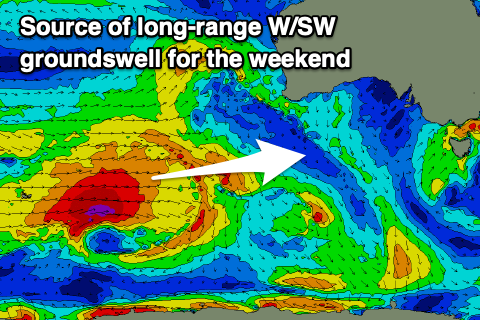
It’ll be inconsistent but good quality with Middleton expected to offer 3-4ft sets at the peak while the Mid Coast should maintain 2ft sets.
Conditions will be best for the Mid Coast into tomorrow afternoon with moderate N/NE winds, tending more variable later and E/NE, while Sunday will see strengthening N/NE-NE winds, tending N/NE into the afternoon favouring the South Coast.
The swell will ease into Monday as stronger N/NW winds kick in, producing building levels of NW windswell across the Mid Coast.
We then look at the strengthening mid-latitude frontal activity moving across us through Tuesday/Wednesday (under the influence of a strong node of the Long Wave Trough), with the first swell producer expected to spawn south of Western Australia on Sunday.
A fetch of W/SW gales will project east through Sunday/Monday, weakening a touch while moving across us Tuesday.
We’re set to see a large mix of groundswell, mid-period swell and windswell building Monday but more so Tuesday/Wednesday.
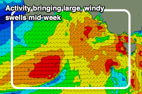
The Mid Coast looks to peak Tuesday with the South Coast seeing the most size Wednesday, likely coming in at a stormy 3-5ft inside the gulf Tuesday with 6-8ft surf across Middleton into Wednesday.
Local winds will be strong from the W/NW-W on Tuesday with strong W tending W/SW winds on Wednesday, favouring protected spots.
Thursday could be the pick as the frontal passage clears leaving variable winds, but more on this Monday.
Following the large windy surf mid-next week we’ve got a secondary pulse of medium-range, moderate + sized SW groundswell on the cards for next weekend but check back Monday for more. Have a great weekend!