Workable waves with a sizey S'ly swell over the coming days

South Australian Surf Forecast by Craig Brokensha (issued Wednesday January 17th)
Best Days: Selected spots early tomorrow morning South Coast, Friday South Coast, Saturday morning South Coast
Features of the Forecast (tl;dr)
- Moderate + sized S/SW swell tomorrow with strengthening SW-S/SW winds (W/NW for a period early around Victor, S/SE on the Mid)
- Reinforcing mod-large S'ly swell Fri with E/NE-NE tending SE winds
- Rapidly easing S'ly swell Sat with N/NE tending S winds
- Gusty S/SE winds Sun with small surf
- Weak S/SE windswell Mon with mod-fresh E/SE tending S/SE winds
Recap
Yesterday was clean and fun in the morning down South, though an onshore changed moved in early, arriving mid-morning and creating gradually deteriorating conditions through the day.
Today is poor with small surf and gusty onshore winds down South, tiny and windswelly on the Mid Coast.

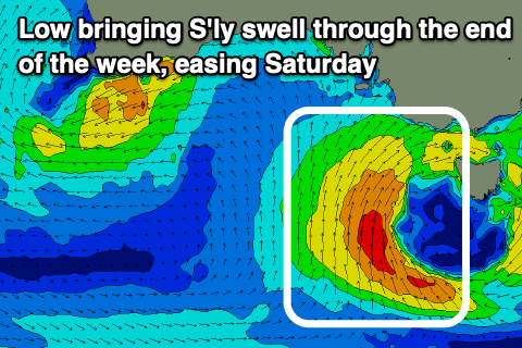
Mid-latitude moving in this morning as the sun rises across the country
This week and weekend (18 - 26)
The interaction between a mid-latitude low moving in from the west and polar front projecting up from the south-west yesterday is now resulting in the deepening of the low to our south today as it stalls.
This will be the main source of swell for the coming days, with a slow moving fetch of strong S/SW tending S winds being projected slowly through our southern swell window from today through tomorrow before drifting east across Tasmania Friday, cutting off the source.
Tomorrow is now looking solid thanks to an initial fetch being projected north towards us, kicking up 4-5ft sets across Middleton, while a secondary pulse of reinforcing S'ly swell is due Friday to 4-6ft.
Unfortunately the Mid Coast isn't due to see any size at all over 1ft or so tomorrow (tiny Friday) thanks to the southerly angle of the swell and blocking effects of Kangaroo Island.
Looking at the local winds and a general, strengthening SW-S/SW flow is due tomorrow but the Victor region should see local topography steer them W/NW for a short period and S/SE early on the Mid Coast.
Friday is still looking good though likely lumpy down South with a light E/NE-NE breeze through the morning ahead of relatively weak SE sea breezes, with Saturday offering great N/NE offshore winds ahead of a trough and S'ly change.
The swell on Saturday will be easing rapidly though with dropping sets from 3ft to possibly 4ft, down to 2ft into the afternoon.
Make the most of these windows of favourable conditions and swell down South, as Sunday looks poor with gusty S/SE winds, possibly improving slightly Monday but with no quality groundswell.
The mid-latitude activity will prevent any other major swell generating activity firing up in the Southern Ocean with next week due to be weak and small. More on this Friday.
Comments
Why are the forecast charts showing E/SE winds for Saturday, but you are calling northerly?
Please don't get our hopes up for 3ft and offshores on Saturday unless its actually going to happen!
We are on an emotional razor's edge at the moment.
Only a surfer knows the feeling!!!
EC has E/NE-NE.
ta
Strongly recommend taking Craig's specific forecasts over automated modelling yahabo
ta