Large swell over the coming days, best in the gulf

South Australian Surf Forecast by Craig Brokensha (issued Monday October 30th)
Best Days: Mid Coast tomorrow morning and late, South Coast tomorrow afternoon, Mid Coast Wednesday, Wednesday morning South Coast for the keen, Thursday morning South Coast
Features of the Forecast (tl;dr)
- Large SW-S/SW groundswell building tomorrow, peaking into the PM with gusty SW-S/SW winds, easing into the PM down South. Mod-fresh S/SE-S winds early on the Mid, strong SW into the PM and then S/SE on dark
- Easing swell Wed with light E/SE-SE winds ahead of sea breezes
- Smaller Thu with E/NE tending S/SE winds
- Small mid-period S/SW swell for Fri AM
- S/SE-SE winds Fri, strengthening into the weekend but with poor levels of S/SE windswell
Recap
The weekend saw clean, easing surf on the South Coast, best across the magnets before bottoming out into yesterday morning.
A new pulse of small W/SW swell filled in though with 1ft sets across the Mid Coast, building to 1-2ft into the afternoon with moderate to fresh onshore winds.
Conditions are poor today with strengthening W/NW winds in the gulf and small 2ft waves off Middleton for the keen, though we've got larger surf to come.

Mushy 1-2ft waves yesterday afternoon
This week and next (Oct 31 – Nov 5)
Today's strengthening winds are linked to a strong Southern Ocean frontal progression moving in from the south-west, with it firing up to the south of the country on the weekend.
We've seen this slow moving frontal progression generating a fetch of strong to gale-force winds, with a great slingshot of gale to severe-gale SW winds being projected through our southern swell window, on top of this active sea state.
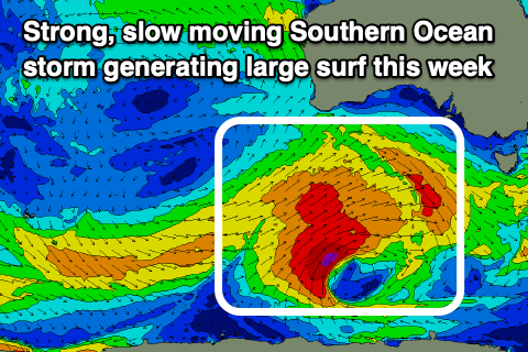
A large SW-S/SW groundswell will be generated for tomorrow, building through the day and peaking during the afternoon. Middleton should come in at 6ft+ with 8ft sets on the deep water reefs while the Mid Coast looks to come in at 2ft to possibly 3ft through the afternoon.
Winds in the wake of the swell generating system will unfortunately be poor and gusty from the SW-S/SW across the South Coast, easing through the day and offering workable conditions into the afternoon. The Mid Coast will likely see S/SE-S winds in the morning, shifting SW through the day and strengthening, shifting back S/SE on dark.
Wednesday looks the pick with easing surf from 5-6ft across Middleton and 2ft waves on the Mid Coast as winds shift E/SE-SE across the gulf, similar down South.
Into the end of the week, a trough sitting to the north-east of a high broadening in the Bight will see E/NE to S/SE-SE winds Thursday, though reverting back to the SE-S/SE on Friday, strengthening through the weekend as the high and trough both deepen.
This will also block our major swell window, with localised S/SE windswell being dominant from the weekend.
Coming back to Thursday's size, easing 3ft+ waves are due off Middleton, tiny 1ft across the Mid Coast, while a reinforcing pulse of small mid-period S/SW swell is due on Friday to 2-3ft. This will be generated by trailing W/NW winds behind the main swell generating system for tomorrow.
Longer term there's nothing too significant at all on the cards for next week so make the most of the coming swell.