Oversized stormy swell to end the week

South Australian Surf Forecast by Craig Brokensha (issued Wednesday February 1st)
Best Days: Mid Coast later this afternoon, South Coast protected spots until the change tomorrow afternoon, novelty spots South Coast Friday afternoon, Mid Coast for the depserate Saturday morning, South Coast Sunday and Monday mornings
Features of the Forecast (tl;dr)
- Moderate sized mid-period SW swell tomorrow with strengthening W/SW winds on the Mid (kicking up a local windswell), W/NW tending W/SW-SW winds mid-late PM down South
- Oversized, stormy SW-S/SW swell building Fri with strong SW winds
- Large, easing S/SW swell Sat with fresh SW winds
- Further drop in size Sun with light SE winds, increasing
- Inconsistent moderate sized SW groundswell arriving later Sun PM, easing Mon with E/NE tending SE winds
Recap
Clean tiny surf to 1.5ft, dropping back from Monday's pulse to 2ft, while today the swell is more windswelly to 1-1.5ft. A better mid-period pulse of swell should be seen this afternoon to 1-2ft.
The South Coast offered plenty of size yesterday morning with average but worakble SE winds, improving into the afternoon with a weaker S'ly breeze.
This morning winds favoured protected spots early with the swell hanging in at 3-4ft but conditions have since deteriorated with a strong S/SE change.
This week and weekend (Feb 1 - 5)
The swell seen the earlier stages of this week is set to be replaced by moderate sized mid-period energy this afternoon and tomorrow, generated by a broad, elongated polar frontal progression pushing in and under the country the last couple of days.
Middleton should hold around 3-4ft with 1-2ft sets on the favourable parts of the tide across the Mid Coast, otherwise 1-1.5ft.
Winds will strengthen out of the W tomorrow as our strong polar low linked to Friday's large, stormy swell starts to project up and into us.
This will kick up a building windswell on the Mid Coast to 2ft+ into the afternoon, while protected spots down South will be clean with strong W/NW winds ahead of a W/SW-SW change mid-late afternoon.
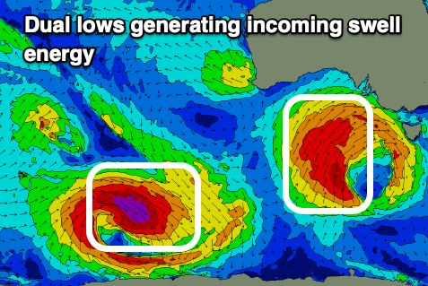
This change will be linked to a strong cold outbreak pushing up and into us, with it taking the form of a polar low that's currently to the south-southwest of Western Australia.
A fetch of severe-gale W/SW-SW winds are being generated on top of an active sea state, with it due to ease slightly while projecting north-east up and into us.
With SW gales being forced up and into us, followed by a final upper-cut during Friday, we can expect the South Coast to become very large through the day, building to 8-10ft into the afternoon but with strong SW winds. The Mid Coast will see stormy 3ft+ waves, with both coasts easing in size Saturday as the low starts moving east.
Gusty SW winds will persist across both coasts Saturday, with an early S/SW'ly on the Mid Coast and easing 2-3ft sets, while the South Coast looks to ease from 6-8ft.
A more noticeable decrease in size is due through the afternoon, with Sunday seeing easing 3ft+ waves with a lighter SE breeze. The Mid looks to be tiny and back to 1-1.5ft.
Into Sunday afternoon, a new, inconsistent SW groundswell is due, generated by a strong extra-tropical low dipping south-east into polar latitudes while strengthening. It will produce a great fetch of severe-gale W/NW winds before weakening tomorrow evening, resulting in a moderate sized groundswell.
Inconsistent but strong 3-4ft sets should arrive into Sunday evening, easing from a similar size Monday morning with what looks to be a lighter E/NE breeze. We'll confirm this on Friday.
Winds will revert back to the SE from Tuesday and with no considerable swell so make the most of the coming energy if you can escape the wind.
Comments
Hey Craig any idea what all the swell and SW winds will do to the fresh water coming from the Murray? I see dead fish have been washing up as far round as Waitpinga. Surely a good swell will mix it up at least?
Surfing-wise, I don't see anything positive from this event. I just got back from NSW after 2 months and I'm frozen today, it's so cold. I wasn't even checking the forecast in NSW, I would just rock up to the beach and surf with the rising sun. Now I'm facing this winter-style event in the middle of summer. On the positive side, it looks good for wing foiling. I had an epic seabreeze session yesterday afternoon and it looks very windy over the next few days. SA makes way more sense when surfing is combined with some wind sports (kite, wing...).
Surely the local councils should be cleaning the beach between Middleton and Goolwa. Especially that it has been school holidays. The East coast does it regularly.