Small windows for the South Coast, fun on the Mid early-mid next week

South Australian Surf Forecast by Craig Brokensha (issued Friday December 30th)
Best Days: Mid Coast today, South Coast this morning, South Coast for the keen tomorrow morning and the Mid for beginners, South Coast Sunday morning, dawn Monday South Coast, Mid Coast late in the day for the keen but more so Tuesday and Wednesday
Features of the Forecast (tl;dr)
- Low point in swell Sat AM with light E/SE-E tending fresh S/SE winds
- Inconsistent SW groundswell for later Sat, easing Sun with N/NE tending S/SE winds
- Moderate sized, inconsistent W/SW swell building Mon with local offshore winds at dawn ahead of a strengthening S/SW change mid-morning, tending S/SE late on the Mid
- Reinforcing W/SW swell for Tue and Wed with strong S/SE-S winds
Recap
Super fun waves on the Mid Coast all day yesterday thanks to a new mid-period W/SW swell with surf mostly to 2ft, kicking a little bigger with the incoming tide under cross-shore winds.
Today we've got slower 1-2ft leftovers but there should be waves most of the day again.
The South Coast was sizey but poor yesterday, cleaner this morning with a cross-offshore wind.

A little windy though with plenty of size yesterday PM
This weekend and next week (Dec 31 – Jan 6)
Tomorrow will become smaller across both coasts, tiny on the Mid and to 2ft across Middleton down South. Winds look similar to this morning and a bit better than low-resolution forecasts. A light E/SE-E breeze is expected on the South Coast before sea breezes develop and freshen. It won't be great but there should be a wave for the keen.
Later in the day a new, inconsistent SW groundswell is due, with it expected to ease back Sunday from 2-3ft across the Middleton stretch. The Mid Coast will be tiny.

This was generated by a short-lived burst of W/SW gales in our medium-range swell window earlier in the week, and while inconsistent, conditions should be nice and clean with a N/NE offshore ahead of S/SE-SE sea breezes.
Of greater significance is our inconsistent mid-period SW swell due into Monday.
The swell was and is still being generated by a great, broad fetch of strong to at times gale-force W/SW winds pushing east from the Heard Island region.
The progression is currently weakening south of the country and we should see the swell arriving Monday, peaking into the afternoon.
It'll be inconsistent but we should see Middleton come in at 3ft+ on the sets along with 1-2ft waves on the Mid Coast.
Winds will be best at dawn for the South Coast, before the swell really kicks with a light N'ly offshore, but a trough will bring a strengthening S/SW change mid-morning, creating poor conditions across both coasts. The Mid should clean up later as winds shift S/SE but lower your expectations.
We'll then enter a poor period of winds for the South Coast as a high sets up camp in the Bight and storms skirt around the southern and south-eastern flank.
This will bring strong S-S/SE winds from Tuesday through at least Thursday, possibly swinging more SE into Friday.
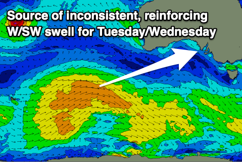
There'll be nowhere to recommend down South during this period, but the Mid Coast is expected to see an inconsistent, mid-period W/SW swell fill in Tuesday afternoon, holding Wednesday morning. This is being generated by a weaker but slightly more northerly tracking frontal system on the back of the progression linked to Monday's swell.
It should maintain 1-2ft sets across the Mid Coast Tuesday afternoon and Wednesday morning, then ease through Thursday.
Longer term the outlook is slow so make the most of the fun windows of waves this period. Have a great weekend and Happy New Year!