Large, powerful swell on the build

South Australian Surf Forecast by Craig Brokensha (issued Monday December 26th)
Best Days: Today both coasts (Mid Coast will be the pick late), South Coast tomorrow, Mid Coast Thursday and Friday morning, Sunday morning South Coast
Features of the Forecast (tl;dr)
- Large W/SW groundswell building rapidly today, peaking into the afternoon/evening, easing tomorrow
- Fresh N/NE tending N/NW then variable winds tomorrow
- Strong S/SW winds with easing surf Wed
- Moderate sized mid-period W/SW swell Thu with fresh SE tending stronger S/SE winds, easing Fri with fresh SE-S/SE winds
- Smaller weekend with S/SE winds Sat, variable Sun AM
Recap
Friday afternoon’s pulse of new swell kicked to 2-3ft with the incoming tide across the Mid Coast, but backed off to 1-2ft later in the day, tiny into Saturday and in the 1ft range. The South Coast offered the best waves Saturday morning with variable winds and clean, lined up sets to 3ft across Middleton but a little inconsistent.
Yesterday a new swell started to fill in and conditions were great across the South Coast again with surf to 3ft. A larger peak in size was seen into the afternoon but with sea breezes.
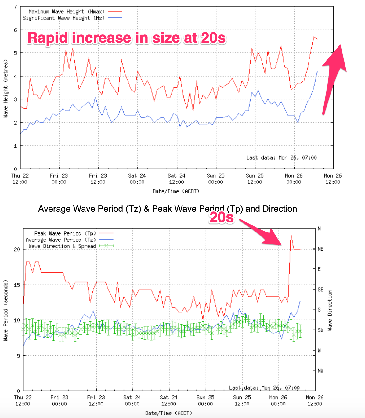
This morning we’ve got our large, long-period SW groundswell on the build. It’s hit the Cape du Couedic wave buoy with strength and we can expect a rapid increase in size across both locations through the day, with step-ladder sets across the South Coast.
This week and weekend (Dec 27 - Jan 1)
Today’s large and rapid increase in SW groundswell is on track, with it generated by a ‘bombing’ low that formed to the south-west of Western Australia last Friday.

Satellite observations (right) picked up an incredible fetch of storm-force winds, and observations from Western Australia confirm we’re looking at step-ladder sets and a rapid increase in size as the swell builds through today.
Middleton should reach 6-8ft with 10ft sets on the deep water reefs around Victor Harbor into this afternoon and 2ft+ waves on the Mid Coast.
This morning’s light offshore winds will give into afternoon sea breezes across both regions, shifting back SE into the evening across the Mid Coast. This will be the pick of the regions.
The swell peak will be fairly short-lived due to the quick east, then south-eastward track of the low, with tomorrow expected to see steadily easing sets from 4-5ft across Middleton and 1-2ft on the Mid Coast.
Tomorrow will be the day to hit the South Coast with fresh N/NE tending N/NW winds, holding into the afternoon and tending variable. This should provide a whole day of excellent surf as the swell eases. The Mid Coast will be wind affected and not great so aim for later today.
Into Wednesday, a mid-latitude front pushing in from the west will bring a W/SW change early morning, quickly shifting S/SW by dawn as it clears quickly to the east.
Now, with the quicker movement of the weakening low pushing east over the coming days, we’ve got a downgrade in the swell expectations from this system.
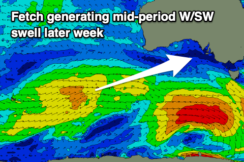
An initial healthy fetch of strong W/SW winds projecting up towards Western Australia will generate some fun, inconsistent mid-period W/SW swell for Thursday, mixed in with some S/SW windswell from the change down South.
The Mid Coast looks to come in around 2ft, with the odd bigger one on the favourable parts of the tide Thursday, while the South Coast will be a junky 3ft+ across Middleton but with fresh SE winds. Afternoon S/SE winds should keep the Mid Coast clean all day.
SE-S/SE winds look to persist on Friday with a drop in size, easing from 1-2ft on the Mid Coast and 2-3ft down South.
Looking longer term and troughy weather look to develop through the weekend, with S/SE winds on Saturday being replaced by variable breezes on Sunday but with small surf. Therefore with the slower outlook from this coming weekend, make the most of the coming swell!
Comments
Incredible readings off Cape du Couedic!
6.7-10.2m of pure groundswell @ 18-20s.
Reports of monster waves on the deep water reefs.
Third Ramp at Robe was the biggest and cleanest I have seen it this morning.Some of the bombies on the horizon I don’t recall seeing break before, and all this in the last week of December.What a crazy year it has been!!!
Awesome.
What a swell. Biggest of the year i think for the southern ocean.
I agree.
Imagine if this event had a bit more west in direction!
Indeed!
Us oldies will be hoping the swell eases to 3-4' by noon tomorrow so we can get out!!!
You get out there? Looks super fun!
Mid Coast air-show..
yep you could really feel the period in the swell on monday they were moving much quicker through the water