Windy, onshore surf

South Australian Surf Forecast by Craig Brokensha (issued Wednesday December 14th)
Best Days: No good days - selected locations South Coast Sunday morning for the keen, similar Monday morning
Features of the Forecast (tl;dr)
- Mid-period S/SW swell Thu, mixed in with S/SE windswell. Fresh S/SE-SE winds, strengthening into the PM from the S/SE
- Easing surf Fri with mod-fresh SE tending strong S/SE winds
- New, moderate sized S/SW groundswell mixed with S/SE windswell Sat with fresh E/SE tending strong S/SE winds
- Easing surf Sun with mod-fresh E-E/SE tending strong S/SE winds
- Smaller Mon with fresh NE tending SE winds
- Small to tiny Tue with NE tending SE winds
Recap
There was a fun window of clean conditions in protected spots with a lift in swell on the South Coast yesterday morning, though the waves deteriorated later morning with a strong SW change. The Mid Coast was a semi-stormy 2ft with a slight improvement in conditions through the afternoon.
This morning we've got more size down South but terrible conditions thanks to a strong S'ly wind, bumpy on the Mid with leftover 1-1.5ft waves.
This week and next (Dec 15 - 23)
Strong S'ly winds are currently bringing up cold air from polar latitudes and we'll unfortunately see winds persistent out of the south-eastern quadrant through the coming days and weekend thanks to a stalling low in the Tasman Sea.
The low will prevent a strong high that's sitting south-west of us, push further east, leaving the state under the influence of the western flank of the low (eastern flank of the high).
A moderate sized mix of S/SE windswell and mid-period S/SW swell energy is due tomorrow (3-4ft Middleton) along with fresh S/SE-SE winds, strengthening later in the afternoon. The Mid Coast will be clean but tiny to flat.
Friday will see the size drop as winds shift more SE, fresh to strong in the morning and then to the S/SE into the afternoon.
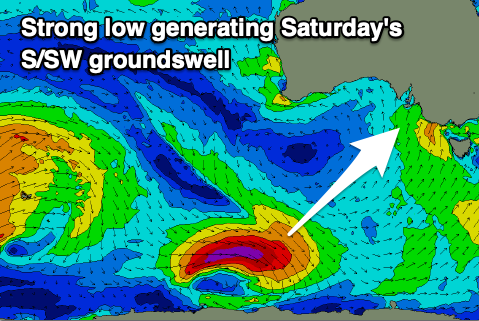
Later in the day Friday, a new S/SW groundswell is expected, with it due to peak on Saturday across the South Coast.
This is being generated by a strong polar low that's formed to the south-southwest of Western Australia, producing a fetch of gale to severe-gale W'ly winds in our swell window.
The swell is due to peak Saturday morning to 3ft to occasionally 4ft across Middleton, 0.5ft on the Mid Coast.
Winds will unfortunately remain average though swing more E/SE through Saturday morning, fresh in strength. Strong S/SE winds into the afternoon and evening will kick up some localised windswell as per the days before, with the windswell and S/SW groundswell due to ease Sunday as winds improve a touch more.

The general flow across the South Coast will be E/SE on Sunday morning but there should be periods of E'ly winds and easing surf from the 3ft range.
As we move into next week, a deepening inland low across Western Australia will start pushing east, pushing the high south of the country, under us through Monday/Tuesday. This looks to bring NE winds on Monday but with weak, easing 2ft waves, smaller again Tuesday but with similar winds.
Swell wise, there's nothing major on the cards thanks to the blocking effects of the strong high, though check back here on Friday for any change to the situation.