Tricky winds with a strong swell Wednesday afternoon

South Australian Surf Forecast by Craig Brokensha (issued Monday December 5th)
Best Days: Keen surfers Mid Coast today and tomorrow morning down South, Thursday for beginners on the Mid Coast, Friday morning and Saturday morning down South
Features of the Forecast (tl;dr)
- Weak, easing S/SE windswell tomorrow with moderate E/NE-NE tending SE winds
- Tiny Wed AM, ahead of a moderate sized + SW groundswell building into the PM, peaking overnight, easing Thu
- Mod-fresh S/SW winds Wed, strengthening into the PM
- Mod-fresh S/SE winds Thu
- Moderate E/NE-NE tending E/SE winds Fri with smaller, easing surf
- Small background W/SW swell Sat PM and Sun with N/NE tending E/SE winds Sat, strong S/SW-SW Sun
Recap
Fun waves across the South Coast magnets for experienced surfers, while Middleton provided perfect conditions for longer boards and beginners. Saturday provided the most size following Friday's easing swell, poor and onshore from early afternoon yesterday with a strong onshore change. The Mid Coast was tiny and effectively flat.
Today onshore winds are persisting on the South Coast with a junky windswell, better than expected on the Mid Coast with cross-shore winds and 1.5ft surf. The Mid has since pulsed to 2ft on the sets and looks worth a paddle with the cross-shore winds.

Good size this afternoon
This week and weekend (Dec 6 - 11)
The trough responsible for yesterday's change and today's windswell is moving off to the east and we'll see winds and conditions improve tomorrow morning down South with an E/NE-NE morning breeze. The swell will be weak and easing, with a S/SE windswell dropping from 2ft on the sets across Middleton. The Mid will ease back from 1ft max.
Moving into Wednesday we'll see another trough pushing up and into us, bringing a moderate to fresh S/SW, strengthening change as the swell bottoms out.
Into the afternoon though a moderate sized + pulse of SW groundswell is expected, with it due to peak into the evening and ease through Thursday.
The evolution of the swell has been brought forward a little compared to Friday's outlook thanks to the core winds around the polar low linked to the swell being a touch stronger.
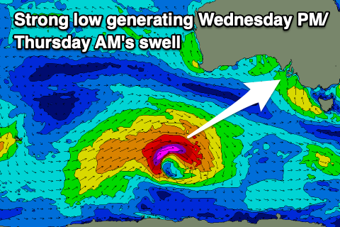
This low is currently south-southwest of Western Australia with a fetch of severe-gale W/SW winds being generated, reaching storm-force at its core. The low will weaken this evening while tracking more south-east towards the polar shelf.
The swell is due to arrive Wednesday morning and build to a solid 4ft into the late afternoon and evening across Middleton, with 1ft sets across the Mid Coast.
The swell is due to come in larger overnight, but then ease Thursday from a similar 4ft across Middleton with 1-1.5ft sets on the Mid Coast.
Winds will start to swing S/SE on Thursday as a high moves in from the west, moderate to fresh in strength, creating average conditions on the South Coast.
A moderate E/NE-NE breeze should provide cleaner options Friday morning as the swell eases back from 2-3ft.
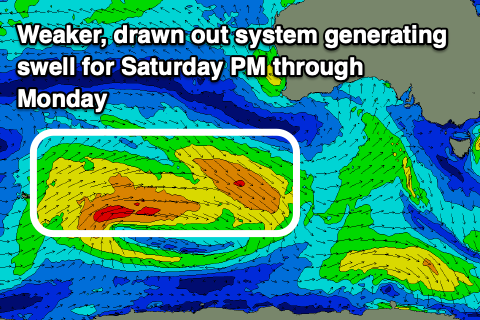
Into the weekend we should see more favourable N/NE winds and small, but fun 2ft waves across Middleton, steadying through the day and also holding Sunday thanks to some small, reinforcing mid-period W/SW swell energy filling in.
The source of this swell will be a broad but relatively weak low developing around the Heard Island region today, moving east over the coming days. The Mid won't see any major size unfortunately and hang around 1ft.
Sunday onwards looks poor as another trough, come deepening low moves in from the west, bringing strong S/SW-SW winds, persisting Monday. Longer term there's nothing major at all on the cards but check back here Wednesday for another update.
Comments
Hey Craig,
Thanks for your ongoing forecasting!
Quick question... what is the time frame in hours from the CDC buoy rising and the swell arriving on the Mid Coast?
Thanks in advance,
Lizzie
Great question and it all depends on the swell period. The higher the period, the quicker the swell travels through the water.
The equation is 2.81*period. So for a 10s swell = 28.1km/h.
For a 16s swell = 44.96km/h.
You then work out the distance which is approximately 190km.
So 190/28.1 = 6.76hrs for the 10s swell and 4.22hrs for the 16s swell.
Thanks so much Craig... this will be extremely helpful!
Dear Huey,
It would be nice if you could deliver some swell on the weekends rather than mid week. Thanks in advance