Fading swell on the weekend, best tomorrow morning

South Australian Surf Forecast by Craig Brokensha (issued Friday December 2nd)
Best Days: Exposed beaches tomorrow morning, Sunday for beginners, Mid Coast for the keen Thursday, Friday South Coast
Features of the Forecast (tl;dr)
- Steady drop in S/SW swell all weekend with a N/NE tending mod-fresh SE breeze tomorrow
- Tiny Sun with mod-fresh N/NE tending N/NW winds, W/NW into the PM ahead of a late SW change
- Strong S winds Mon with a building S windswell
- Tiny W/SW swell Mon
- Moderate + sized SW groundswell for later Wed, peaking Thu with E/SE-SE tending S/SE winds
- Easing surf Fri with gusty NE tending E/SE winds
Recap
Winds shifted more east-southeast across the South Coast yesterday morning with plenty of size still coming in at 3-4ft, but options were limited. Later in the afternoon the large pulse of S/SW groundswell filled in, but conditions were poor thanks to a S/SE sea breeze.
This swell was still solid at dawn with inconsistent 4-5ft sets out of the south along with cleaner, though still lumpy conditions.
The Mid Coast was 1ft through the morning yesterday, pulsing a touch to 1-1.5ft into the afternoon, while this morning we're back to 1ft surf.
This weekend and next week (Dec 3 - 9)
Tomorrow morning looks to be the pick of the weekend with the current swell due to ease back steadily in size, bottoming out on Sunday and becoming tiny.
Tomorrow morning should still be a fun 2ft+ across Middleton, better at the swell magnets, easing through the day and back to 1-1.5ft on Sunday. The Mid Coast will become tiny to flat and a light to moderate N/NE offshore will create great conditions down South ahead of moderate to fresh SE sea breezes.
Sunday looks clean most of the day with a moderate to fresh N/NE tending N/NW breeze, then W/NW into the afternoon ahead of a late SW change. Unfortunately the swell will be tiny though.
Our small pulse of mid-period S/SW swell expected into Sunday afternoon has been delayed and downgraded unfortunately, with the weak front generating it now only due to form late in our swell window.
This swell has been pushed back to Monday morning and only looks to come in at 1-2ft, but conditions will be poor thanks to a strong S'ly wind in the wake of Sunday evening's change.
We'll see poor surf for the early to mid stages of the week thanks to persistent SE-S/SE winds through Tuesday, Wednesday and Thursday. Monday will see a small pulse of S'ly windswell from the strong south winds, fading into Tuesday and gone Wednesday.
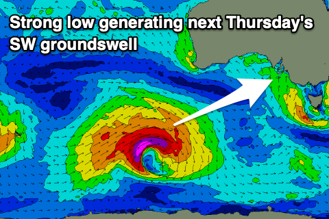
Into later Wednesday but more so Thursday, a good sized SW groundswell is due across both coasts, generated by a strong polar low forming to the south-southwest of Western Australia on the weekend.
A fetch of severe-gale W/SW winds will be generated in our medium-range swell window, with the low weakening while pushing east through early next week.
A peak to 4-5ft is due on Thursday morning across Middleton, 1-1.5ft on the Mid Coast.
A morning E/SE-SE breeze will favour the Mid Coast on Thursday, cleaner down South on Friday with a NE breeze and easing swell. The weekend looks cleaner again but with fading surf, best Saturday morning.
We'll have a closer look at this on Monday though. Have a great weekend!