Large swell to end the week but with less than ideal winds
South Australian Surf Forecast by Craig Brokensha (issued Wednesday November 30th)
Best Days: Tomorrow afternoon Mid Coast for the keen, South Coast Friday morning, Saturday morning and Sunday early-mid afternoon
Features of the Forecast (tl;dr)
- Large S/SW groundswell building Thu PM with mod-fresh E/SE tending stronger S/SE winds
- Easing S/SW groundswell Fri with light-moderate E/NE-NE tending S/SE winds
- Easing surf Sat with N/NE tending S/SE winds
- Small new swell Sun PM with N/NE tending weak S/SE winds
- Easing surf Mon with S/SW winds
- Tiny, inconsistent W/SW swell for Mon
Recap
The Mid Coast saw slightly cleaner waves yesterday but the big morning high tide swallowed all the 1.5ft sets, with bumpier conditions into the afternoon. Today the swell is similar in size and cleaner but again swallowed by the tide. Try the afternoon for a surf.
The South Coast has seen plenty of size the last two mornings, bumpy and average yesterday while a weaker onshore wind is creating more workable options this morning.
This week and next (Dec 1 - 9)
Looking at the outlook for the end of the week and we've got a large S/SW groundswell due across the South Coast as winds slowly improve, though the weekend looks the cleanest but much smaller.
Coming back to tomorrow, and a new SW groundswell that's due to peak through today down across the South Coast (4-5ft sets) should ease into tomorrow, dropping back to the 4ft range on the sets through the morning.

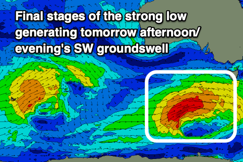
We should see a stronger pulse in size through the afternoon, generated by a strong low that's been moving under the country the past couple of days.
The low is currently south-west of Tasmania, generating a fetch of W/SW gales, but earlier in its life, stronger severe-gales were produced, and this should see strong sets pushing towards 6ft into the afternoon across Middleton and deep water reefs across the South Coast. Inconsistent 1-2ft sets are due on the favourable parts of the tide in the gulf, with easing surf from 1-1.5ft due on Friday morning, 4-5ft across Middleton down South.
Looking at the local winds, and tomorrow will remain average with a moderate to fresh E/SE breeze, strengthening from the S/SE into the afternoon as the large S/SW groundswell fills in.
Friday will be a touch better but tricky with the size under a light to moderate E/NE-NE breeze before S/SE sea breezes kick in early afternoon.
Come the weekend, the swell will be much smaller, easing from 2ft+ across Middleton on Saturday morning (tiny to flat on the Mid Coast) but with better N/NE winds in the morning ahead of the S/SE sea breeze.
Moving into Sunday and the surf looks to start slow and to 1-2ft, but into the afternoon a small pulse of mid-period S/SW swell is due, generated by a weak, late forming low (in our swell window) to the south-west of Tasmania Friday evening.
It'll only be small but a lift back to a more consistent 2ft is due across Middleton into the afternoon, and winds should be OK, N/NE in the morning with weak S/SE sea breezes.
This swell will fade Monday and a trough looks to bring a S/SW change on dawn, creating average conditions across both regions. It's worth noting there'll be a tiny, inconsistent W/SW swell on the Mid Coast Monday, generated in our far swell window and likely not getting above an inconsistent 1ft.
Longer term it looks like a high will move in slowly behind Monday's change, bringing poor S'ly winds for the rest of the week. This will spoil a moderate sized SW groundswell that's due late in the week, but check back here on Friday for more details on this.

