Windy small surf, building next week

South Australian Surf Forecast by Craig Brokensha (issued Friday November 25th)
Best Days: South Coast this morning, South Coast tomorrow after lunch through until late afternoon, South Coast for the keen early Monday, Mid Coast Wednesday morning, South Coast Wednesday morning, South Coast Friday morning
Features of the Forecast (tl;dr)
- Small mid-period swells Sat, peaking into the PM with strong N/NW winds, giving into a late PM SW change
- Smaller Sun with mod-fresh SW winds
- Moderate sized mix of SW swells Mon with freshening W/SW-SW winds
- Secondary moderate sized SW swell building Tue with mod-fresh SW tending S/SW winds
- Larger S/SW groundswell for Wed with moderate S/SE winds, freshening
- Easing surf Thu with mod-fresh SE winds, increasing
- Easing moderate sized swell Fri with E/NE-NE tending SE winds
Recap
The surf was on the slow improve yesterday with plenty of size but lumpy conditions after days of onshore winds. Middleton was still 3-4ft and best late morning before sea breezes kicked in.
Today the swell has dropped back to 2ft to occasionally3ft and the offshore wind is strengthening, ironing out early morning lumps and favouring the exposed beaches.
The Mid was tiny yesterday with lumpy/bumpy conditions through the afternoon, clean early this morning but flat. Winds are due to swing back to the E/SE through this afternoon down South so surf this morning.

Windy 2-3ft peaks this AM
This weekend and next week (Nov 26 – Dec 2)
Tomorrow will be the pick of the weekend as a mix of small, mid-period S/SW swells arrive down South and offshore winds will create good but windy conditions.
The source of these swells was a weak low moving through our swell window during the middle of the week, south-southwest of Western Australia, with inconsistent 2ft sets due into the afternoon at the peak, smaller and 1-2ft in the morning. The Mid Coast will remain tiny to flat.
An approaching frontal system will bring strong N/NW winds in the morning, not ideal with the small surf, holding into the afternoon but hopefully a touch better as the S/SW energy peaks. A late afternoon SW change is due, so get in before then.
 Come Sunday winds look to linger out of the SW, creating poor conditions along with no decent increase in size following Saturday evening's change. The Mid Coast will see a tiny, weak windswell, as will the South Coast.
Of greater importance is the swell inbound through next week across the state, generated by a healthy and strong polar frontal progression developing south of the country.
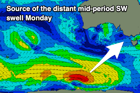
Firstly, a polar front moving east along the shelf yesterday and today, south of Western Australia should generate a mid-period SW swell for Monday. A fetch of sub-gale-force W/NW winds will provide inconsistent 3ft sets across Middleton, though tiny again on the Mid Coast.
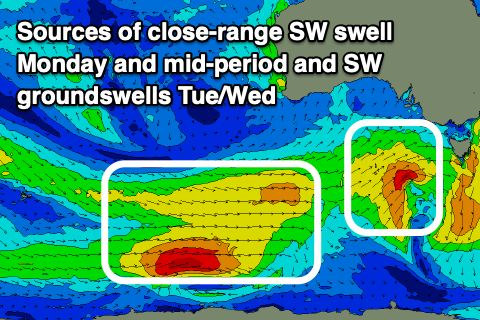
There'll be a more consistent, localised mid-period SW swell present though, generated by Saturday/Sunday's strengthening frontal system, with a burst of strong W/SW winds aimed mostly into Victoria. This should produce more consistent, similar sized 3ft waves Monday, 1-1.5ft max on the Mid Coast.
 Winds look to freshen from the W/SW-SW through Monday, with an early period of lighter W/NW breezes likely early around Victor.
Now, looking at Tuesday/Wednesday, we've got building mid-period SW energy ahead of some less consistent S/SW groundswell thanks to a strong polar low pushing in from the Heard Island region. Initially and at distance to us, a fetch of strong to gale-force W/NW tending W winds will produce a SW groundswell for Wednesday, while the remnants of the low are due to project up slowly towards us early next week, with some mid-period SW energy due to build on Tuesday.
Winds look dicey Tuesday and moderate to fresh SW tending S/SW down South with Middleton building to a consistent 4ft into the afternoon while the Mid looks to kick a touch to an inconsistent 1-2ft.
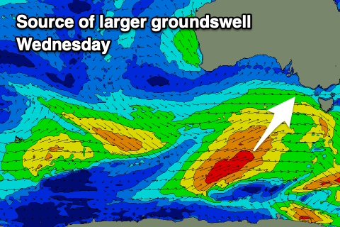 Wednesday looks better with the peak in S/SW groundswell and a light to moderate S/SE morning breeze. While not ideal ,with the strength of the swell to 4-6ft across Middleton and deepwater reefs, there should be some fun options ahead of fresher afternoon sea breezes.
The Mid Coast should hold 1-2ft and be cleaner with the S/SE morning breeze.
A high will edge in from the west through the second half of the week as the size eases across both coasts. Less favourable and freshening SE tending S/SE winds. Friday looks a bit cleaner with a morning E/NE-NE breeze and moderate sized, easing surf thanks to a likely reinforcing mid-period SW swell. More on this Monday. Have a great weekend!