Good S'ly swell with improving conditions

South Australian Surf Forecast by Craig Brokensha (issued Wednesday November 23rd)
Best Days: This afternoon South Coast, tomorrow morning South Coast, Friday morning South Coast, Saturday late morning through mid-afternoon South Coast
Features of the Forecast (tl;dr)
- Moderate sized + S groundswell for late this afternoon/evening with light-moderae S/SW-S winds
- Easing S groundswell tomorrow with N/NW winds ahead of S/SE sea breezes late morning
- Smaller Fri with moderate N/NE-NE winds ahead of fresh E/SE sea breezes
- Small mid-period swells Sat, peaking into the PM with strong N/NE tending N/NW winds through the morning and W/NW into the PM ahead of a late SW change
- Smaller Sun with fresh W/SW tending SW winds (likely W/NW early in Victor)
- Moderate sized SW swell Mon with SW winds
- Moderate sized swells for the rest of next week with SW winds, likely W/NW early each morning
Recap
Solid surf continued across the South Coast yesterday as early W winds favoured protected spots before reverting back to the SW for the rest of the day. The Mid Coast saw slowly easing winds and improving conditions with 2-3ft sets on the beaches and reefs for the keen.
This morning the swell has faded on the Mid as weak onshore winds continued to create bumpy conditions. The South Coast was best in protected spots again and back to 3-4ft. Winds will shift back SW and then S/SW but without too much strength this afternoon. Our stronger pulse of S'ly groundswell for late this afternoon is on track with it showing well on the Cape Sorell wave buoy, and also currently impacting the Surf Coast. Sets should kick to a strong 5ft by dark this evening with that workable onshore wind.
This week and next (Nov 24 - 27)
With the strong cold outbreak releasing its grip on the state, pushing further east, we'll see conditions improve considerably through the end of the week for the South Coast, along with some sizey sets tomorrow, smaller into Friday.
This evening's S'ly groundswell is due to peak overnight and ease back from an inconsistent 4ft on the sets across Middleton tomorrow morning under a light N/NW offshore wind. S/SE sea breeze will kick in from late morning so don't dawdle.
Friday looks smaller and back to 2ft+ across Midldeton but with a good N/NE offshore, moderate in strength ahead of fresh E/SE sea breezes. The Mid Coast will be clean but tiny through the coming days.
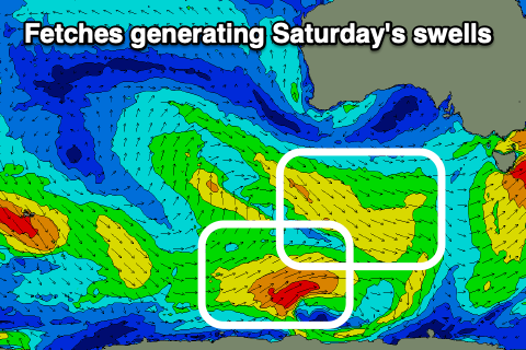 Moving into the weekend and small pulses of mid-period SW and then better S/SW swell are due through Saturday, generated by a low that's currently south-southwest of Western Australia.
A weak fetch of W/NW winds will be followed by slightly stronger polar SW winds. The W/NW fetch will generate a small swell for Saturday morning, to 1-2ft across Middleton, with the SW fetch generating a better S/SW pulse that will arrive late morning and peak into the afternoon to a more convincing 2ft across Middleton. Owing to the south direction of the swells, the Mid won't see any size.
It'll be windy but clean down South as an approaching frontal system brings strong N/NE tending N/NW winds through the morning, shifting W/NW into the afternoon ahead of a shallow SW change.
 This change will be related to another strengthening polar frontal progression firing up through our south-western and southern swell windows, producing moderate sized swell pulses through next week.
Unfortunately the action will be aimed into Victoria, and a ridge of high pressure will sit across us, bringing winds from the south-western quadrant. We'll likely see periods of more favourable W'ly winds each morning but check back here Friday for a clearer idea on the timing and sizes.
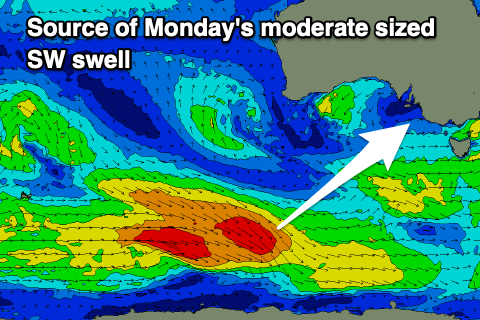
Regardless, a fun sized mid-period SW swell is due into Monday, generated by a healthy polar front firing up around the Heard Island region today. Strong to sub-gale-force W/NW-W winds should produce good 3ft surf across Middleton next Monday but with that SW flow. More on this Friday.