Sizey swells as winds slowly ease and improve

South Australian Surf Forecast by Craig Brokensha (issued Monday November 21st)
Best Days: Protected spots South Coast tomorrow morning and Wednesday morning, Mid Coast for the keen mid-late morning Wednesday, South Coast Thursday and Friday mornings
Features of the Forecast (tl;dr)
- Easing size on the Mid Coast over the coming days
- Moderate sized mid-period S/SW swell tomorrow, easing temprarily Wed AM ahead of a new S groundswell late Wed, easing Thu
- Strong W/SW winds tomorrow, easing into the PM (W/NW for a period around Victor early-mid AM)
- Moderate W/NW tending SW then S/SW winds down South Wed, moderate SW tending lighter W/SW on the Mid
- Easing S swell Thu with N/NE tending S/SE winds
- Smaller Fri with mod-fresh N/NE tending E/SE winds
- Small, S/SW swell for Sat with strengthening NW tending W/NW winds
Recap
Clean but small surf on Saturday with the reinforcing pulse of S/SW energy not really amounting to much unfortunately, coming in at a slow 2ft across Middleton. The magnets were best through the morning. Sunday was smaller again and average with strengthening winds out of the west which kicked up a stormy increase in windswell on the Mid Coast, reaching 4ft into the afternoon.
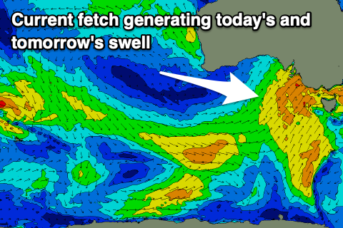
Today the swell is still a stormy 3-4ft on the Mid Coast thanks to the strong, slow moving cold outbreak pushing across us, and the South Coast has increased in size thanks to the backside of the progression generating a mid-period SW swell.
This week and next (Nov 22 - 27)
 This secondary bout of cold, windy and winter like weather is thanks to a strengthening cold outbreak pushing in from the west on the weekend, with it originating at polar latitudes, to the south-west of Western Australia last week.
It's now moving east while continuing to generate a fetch of strong SW-S/SW winds aimed mainly in the South Coast's swell window, bringing the spike in size seen today.
While the main front will clear further to the east tomorrow, a stronger polar frontal system will be drawn up from the south, with a fetch of S/SW gales due to be generated through our southern swell window this evening and tomorrow morning.
What we'll see across our regions is the swell easing across the Mid Coast thanks to the swell origin swinging more south, with easing 2ft to occasionally 3ft sets tomorrow, smaller and to 1-2ft on Wednesday.
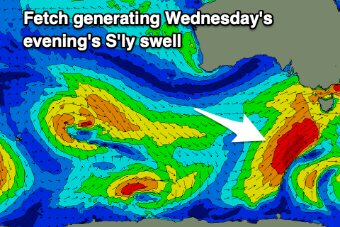 The South Coast will see mid-period S/SW swell energy holding tomorrow in the 4-5ft range, easing back to 4ft Wednesday morning while the S'ly groundswell from the stronger gales should arrive through Wednesday afternoon and peak into the evening to the 5ft range, easing Thursday from 4ft or so.
Looking at the local winds and a strong but easing W/SW breeze is due tomorrow, highly likely W/NW for a few hours around Victor, better Wednesday morning with a moderate W/NW breeze, shifting SW mid-late morning and then S/SW into the afternoon. The Mid Coast will see a slight improvement in conditions as moderate morning SW winds, ease and tend lighter W/SW.
Thursday will be clean but tiny on the Mid Coast, great down South with a N/NE offshore, giving into S/SE sea breezes into the afternoon, great again Friday with a fresher morning N/NE breeze but fading 2-3ft sets.
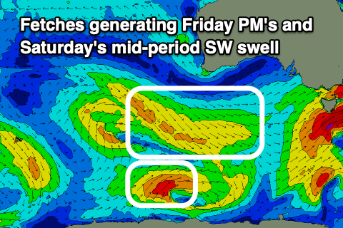 A small, mid-period SW swell is due into Friday evening, with a secondary pulse for Saturday, generated by a weak frontal system moving through the Southern Ocean, producing a fetch of strong W/NW winds, and polar SW winds just behind it.
Only small 2ft waves are expected across Middleton, tiny on the Mid Coast and a new frontal progression moving in from the west looks to bring strengthening NW tending SW winds, but we'll have a closer look at this Wednesday.