Fun South Coast tomorrow, windy and stormy from Sunday

South Australian Surf Forecast by Craig Brokensha (issued Friday November 18th)
Best Days: South Coast today, South Coast tomorrow morning, protected spots for the keen South Coast Tuesday and Wednesday mornings, Thursday and Friday South Coast
Features of the Forecast (tl;dr)
- Fun SW groundswell for Thu PM, peaking this morning with strong N/NE-NE winds
- Reinforcing mid-period SW swell Sat AM, then easing with fresh N/NE winds, tending N/NW late AM, NW into the PM and W/NW later
- Stormy increase in swell for the Mid Coast Sun, easing slowly Mon with strong W/NW tending W winds Sun
- Large stormy SW swell Mon with strong W/SW tending SW winds, easing Tue with gusty W/SW tending SW winds (possibly W'ly early around Victor)
- Easing S/SW swell Wed with W/NW tending SW winds
- Reinforcing S/SW swell Thu with N/NE tending variable SE winds
- Easing surf Fri with N/NW winds
Recap
Conditions started to improve through yesterday with morning offshore winds and peaky, clean 2-3ft waves across Middleton, remaining favourable until mid-afternoon. Today we’ve got a new pulse of SW groundswell and good winds again with 3ft sets across Middleton/Goolwa. Winds should strengthen and swing more N/NE, so pick your spot wisely into the afternoon.
The Mid has been tiny and clean in the mornings, a little wind affected today.
This weekend and next week (Nov 19 - 25)
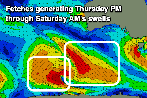 Today’s SW groundswell will ease off a little this afternoon but a reinforcing pulse of slightly weaker SW swell is due tomorrow morning, then fading through the afternoon and further Sunday.
The source of this swell was the backside of a strong but slightly average structured polar low that formed to the south-west of Western Australia early this week. The pre-frontal NW fetch generated today’s size, while post-frontal and less favourably aligned but persistent SW winds will generate tomorrow morning’s size.
Middleton should ease back from an inconsistent 2-3ft with fresh morning N/NE winds, shifting N/NW late morning and then NW through the afternoon and W/NW into the afternoon. With this, surf the exposed beaches before winds go to the west. The Mid will be tiny with a weak increase in windswell through the afternoon.
Moving into Sunday and the cold outbreak that’s currently across Western Australia will start moving across us, bringing strong W/NW tending W winds and a developing stormy swell on the Mid Coast.
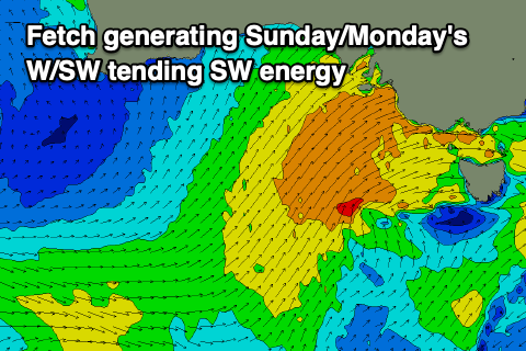 Now, looking at the progression as a whole, and as expected it’s changed a little with the swell now due to come mostly from the west initially, with a south-west component as it starts to ease.
Instead of a tight, strong low forming south-west of us in the wake of Sunday’s change, we’re now due to see the initial front moving in from the Bight doing most of the heavy lifting, generating a fetch of strong, slow moving W/SW winds, with strong SW winds projected up and into us Sunday evening and Monday.
This will result in the Mid Coast seeing all the size initially, followed by the South Coast into Monday, slowly easing through Tuesday/Wednesday as the progression continues east.
The Mid is likely to build from 2-3ft Sunday morning to 3-4ft into the late afternoon/evening with the strengthening winds, easing back from a stormy 3-4ft on Monday morning.
The South Coast may see 2ft sets across Middleton later Sunday, but Monday will see stormy 5-6ft waves but with strong W/SW tending SW winds. Options will be limited and not great so if chasing somewhere down South, lower your expectations.
 As the progression clears to the east we’ll see the size ease but with persistent, gusty W/SW tending SW winds on Tuesday, possibly W/NW for a period in the morning around Victor. The swell will drop back from 4-5ft, while the Mid looks to ease back from 2-3ft.
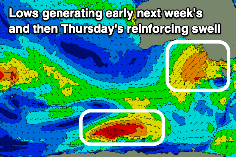
Wednesday looks to be a little cleaner again with a longer lasting W/NW breeze across the South Coast but Thursday and Friday are the pick with more favourable N’ly winds and a reinforcing pulse of fun sized S/SW swell.
This will be generated by a tight but strong polar low on the back of the progression moving through from Sunday, and should keep Middleton around 3ft on Thursday before easing Friday. We’ll have a closer look at this Monday. Have a great weekend!