Improving surf, large, cold and stormy from Sunday PM

South Australian Surf Forecast by Craig Brokensha (issued Wednesday November 16th)
Best Days: South Coast tomorrow morning but more so Friday, South Coast Saturday morning, protected spots South Coast all next week
Features of the Forecast (tl;dr)
- Easing surf Thu AM with moderate E/NE-NE tending fresh E/SE winds
- Fun SW groundswell for Thu PM, peaking Fri AM with strong N/NE winds
- Reinforcing mid-period SW swell Sat AM, then easing with moderate N/NW winds, strengthening from the W/NW into the PM ahead of a late W change
- Stormy increase in swell for both coasts Sun/Mon with strong W/NW winds Sun, strong W/SW Mon (W/NW for a period early Victor)
- Large S/SW swell for Mon PM, easing Tue with gusty W/NW tending W/SW winds
Recap
The Mid Coast cleaned up into yesterday morning with the drop in local winds but the surf was still lumpy and dropped quite a bit in size, swallowed up by the morning high tide. Better waves were seen into the afternoon in and around the low tide, with workable 1-2ft sets for the keen.
The South Coast remained poor and onshore with strong S'ly winds and plenty of size but n quality. Today winds have eased back a little and the swell is still in the 3-4ft range but for the keen. The Mid is back to 1ft and lumpy with cross-shore winds.

Fun waves on the low tide yesterday PM
This week and next (Nov 17 - 25)
 The slow moving low linked to the current cold weather, S'ly winds and S'ly swell is shifting east, and this will result in a drop in size and improving conditions across all locations tomorrow.
The surf looks to ease back to 2-3ft across Middleton, tiny to flat on the Mid Coast with an E/NE-NE breeze across the South Coast, fresher E/SE into the afternoon.
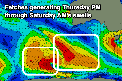
We should see a new pulse of SW groundswell arriving into the afternoon, peaking Friday morning, with a secondary reinforcing pulse of SW energy for Saturday morning.
As touched on in Monday's notes, a strong but slightly poorly structured low (for swell generation across our state) has generated a fetch of pre-frontal NW gales, producing later tomorrow afternoon's pulse of SW groundswell, while a trailing fetch of strong to near gale-force SW winds on the back will generate the slightly weaker reinforcing swell for Saturday morning.
 The first pulse should come in around 3ft on the sets (later tomorrow and Friday morning) across Middleton, tiny and 0.5ft on the Mid Coast and a strong N/NE breeze will create generally favourable conditions all day Friday. The reinforcing swell looks to be slower but still 2-3ft Saturday morning, easing through the day with moderate to fresh N-N/NW winds, strengthening from the W/NW later in the day and stronger W into the evening.
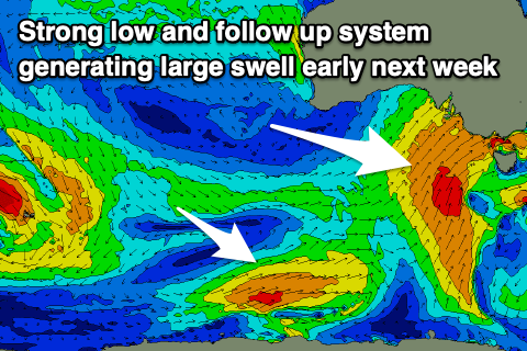
This change in weather and wind will be linked to another strengthening cold outbreak pushing up and across us, bringing large windy surf into early next week across the South Coast and stormy waves on the Mid Coast Sunday.
The progression will actually originate from a polar low that's currently south-west of Western Australia. This low will project north-east up and into the Bight while weakening, but then re-strengthening on approach to Adelaide.
 This will bring strong winds our of the western quadrant and what looks to be 4ft of stormy swell on the Mid Coast Sunday afternoon/Monday, while the South Coast will see gale-force S/SW winds at the southern flank of the low generating large surf through Monday/Tuesday.
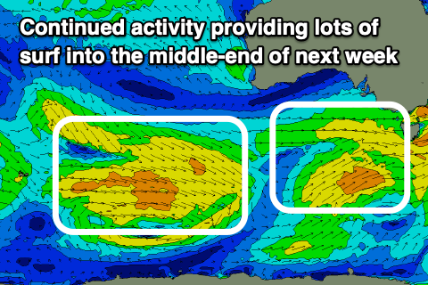
The timing and sizes will move around as we near clearer to the event, but continued frontal activity through next week should produce favourable winds out of the W for protected spots down South.
Check back here on Friday for a clearer idea on the sizes and local winds.
Comments
...and the Year of the Turd continues....
Turd water
picture from middleton cam
Try uploading your image to https://imgur.com/
Then copy the image URL once complete and past it between [img] [/img] tags.
nice one
https://imgur.com/aKK5dDP
Ah yep..