Fun Mid Coast waves tomorrow, South Coast later week

South Australian Surf Forecast by Craig Brokensha (issued Monday November 14th)
Best Days: Mid Coast tomorrow morning, South Coast Thursday morning, Friday and Saturday ahead of the change
Features of the Forecast (tl;dr)
- Moderate sized mid-period S/SW swell building Mon PM, peaking Tue with mod-fresh S/SW winds (S/SE in the AM on the Mid)
- Moderate sized S swell for Tue PM, easing Wed with moderate S winds
- Easing surf Thu AM with E/NE-NE tending SE winds
- Fun SW groundswell for Thu PM, peaking Fri with strong NE winds, easing and tending N/NW
- Reinforcing mid-period SW swell Sat AM, then easing with N/NW winds ahead of a strong W/SW change into the late PM
- Stormy increase in swell for both coasts Sun/Mon with strong W/SW winds Sun and SW winds Mon
Recap
Well what a wild weekend! The deepening mid-latitude low drifting down from the north-west definitely packed a punch and was loaded with tropical moisture.
Conditions and winds played out pretty much to plan as it moved down across us, fairly average and wind affected Saturday morning, deteriorating into the afternoon before trying to clean up on dark Saturday after the storms cleared.
I wasn't keeping an eye on the rainfall totals but the flash flooding experienced down around Middleton, capture by Andy Smyth was incredible and caused quite a bit of damage. If you're still around to lend a hand, I'm sure most would appreciate it.
Yesterday was clean down South but small to tiny, while the Mid Coast saw an increasing windswell as we fell under the backside of the low.
Today both coasts are a mess with strong SW winds and a building swell down South, semi-stormy and 3ft on the Mid Coast.
This week and weekend (Nov 15 - 20)
We've got a poor couple of days ahead for the South Coast as the low from the weekend has drawn up a secondary system from the south today, projecting an additional fetch of strong S'ly winds in our southern window.
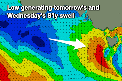 This will generate a moderate sized mid-period S'ly swell for tomorrow, peaking into the evening but with moderate to fresh S'ly winds. The Mid Coast will be the pick as today's windswell eases back from the 2ft range under a morning S/SE breeze.
The S'ly swell will ease back through Wednesday but winds will remain moderate out of the S'th, creating bumpy conditions. Size wise the South Coast should kick to 4ft tomorrow afternoon and then ease from a similar size Wednesday morning.
Come Thursday winds will shift E/NE-NE creating improving conditions along with smaller 2-3ft waves in the morning.
Into the afternoon though some new SW groundswell is expected, holding Friday, followed by a secondary pulse Saturday morning.
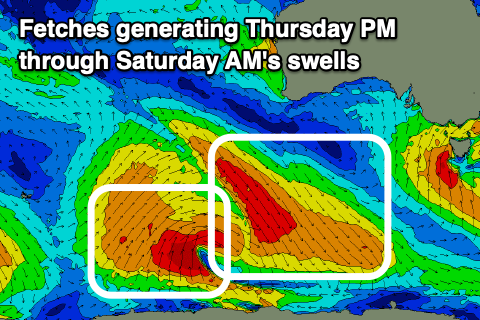 These swells will be generated by a strong but poorly structured low firing up to the south-west of Western Australia. We're interested in both the north-eastern and south-western flank of the low. The north-west fetches around the north-west flank will generate an increase in size Thursday afternoon and Friday morning, with the south-western fetch, on dark Friday and Saturday morning.
Both pulses look to be in the 2-3ft range across Middleton, tiny on the Mid Coast. Both Friday and Saturday look good for the South Coast with a gusty NE breeze Friday morning, shifting lighter N into the afternoon as a strong cold front starts to move in from the west. Saturday should then see lighter N/NW winds ahead of a late, strong SW change followed by strong W/SW winds on Sunday.
The change will be attached to a strong cold outbreak, with a localised, stormy increase in swell due on the Mid Coast Sunday and Monday, while the South Coast will jump in size but with strong SW winds. It looks like a high will fill in behind the cold outbreak early-mid next week, bringing S'ly winds as the swell eases, but we'll have another look at this Wednesday.
Comments
For those who missed it, here's the video of the flash flooding through Middleton creek.
Incredible. Hard to know how much rain fell as there doesn't seem to be any gauges in the catchment area (nearest are Victor Harbor West, Hindmarsh Island, Inman Valley, Finnis etc). Highest regional total seems to be around the 50mm range though I suspect locally it must have been significantly higher.
Fascinating though... these kinds of totals are a regular occurrence on the East Coast, but the catchments are conditioned for them, so the effects are less noticeable. But SA doesn't receive short duration, high intensity rainfall events like this very often, hence the local flooding.
Andy S on it again with today’s WOTD. What a bomb!
And Fraser is only 15! Charging, much like his Dad.
Thought he looked pretty young! Sensational effort.
This is crazy. The weather around the country is wild on all fronts, really sick of it. @craig will this weather ever go back to something 'normal' or 'average'?
Thanks Andy for the footage, that was a wild afternoon. My youngest got flooded out and called for some help, Waterport Road was awash, glad he didn't live in Middleton, who would've thought that could happen so quickly.
Young FG is having a real go on that one, good effort.
middleton : where even the floods are below average