Shifting winds with building swells

South Australian Surf Forecast by Craig Brokensha (issued Wednesday November 9th)
Best Days: Today South Coast, tomorrow South Coast, Friday South Coast, Saturday afternoon/evening, next Wednesday morning South Coast
Features of the Forecast (tl;dr)
- Moderate sized mix of S/SW swells building tomorrow, holding Fri AM then easing
- NW tending W/NW winds early tomorrow PM, shifting gusty SW late PM/evening
- Light S tending S/SE winds Fri, possibly W/NW at dawn in Victor
- Easing S/SW swell Sat with strong E/SE tending E/NE winds late AM, NE into the PM
- Small to tiny surf Sun with strengthening W/NW tending W/SW winds
- Building W/SW windswell on the Mid Coast Sun PM, peaking Mon with strong SW winds
- Moderate sized mid-period S/SW swell building Mon PM, peaking Tue with fresh S/SW winds
- Easing surf Wed with NE tending E/SE winds
Recap
Great conditions for the swell magnets continued across the South Coast yesterday and today, with 2ft peelers for bigger boards off Middleton and Goolwa. The Mid Coast was 0.5-1ft, pulsing to 1ft with the incoming tide yesterday, providing a few waves for beginners, tiny to flat today.
This week and next (Nov 10 - 18)
Looking at the outlook for the rest of the week, and tomorrow morning is the pick with offshore winds from the NW due to tend W/NW into the early afternoon ahead of a SW change into the late afternoon/early evening.
This will be thanks to a weakening mid-latitude low moving in from the west, but there's no swell due from the backside of it for the Mid Coast, just inconsistent levels of SW-S/SW energy from a polar low that developed in our far swell window last weekend.
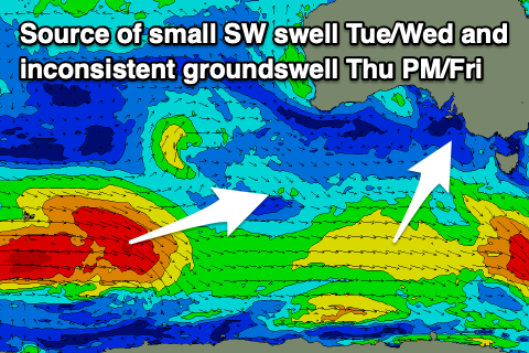 This low generated a great fetch of W/NW and W/SW gales in our far swell window, weakening while moving under the country the past couple of days.
A moderate sized mix of mid-period S/SW swell and infrequent groundswell are due into tomorrow, with the former offering 3ft sets in the morning, pulsing a little stronger to 3ft to occasionally 4ft across the Middleton stretch into the afternoon, easing from a similar size Friday morning.
The Mid should see 1ft waves into tomorrow and Friday on the favourable parts of the tide.
Winds in the wake of tomorrow evening's change will ease into Friday morning but likely linger from the S tending S/SE down South, creating bumpy but workable conditions. There's a chance for an early W/NW breeze around Victor so keep an eye on the local wind observations. Either way with the light local winds and good swell, it'll be a fun surf day.
Into the weekend we'll see easing surf and winds are tricky as a deepening inland low to our north-west drops into the Bight. This will bring strong E/SE tending E/NE winds late morning Saturday, NE into the afternoon. Improving conditions should be seen, best later in the day along with easing S/SW energy from 2-3ft across Middleton in the morning on the sets. The Mid will be clean but tiny.
 Winds will remain strong and continue their anti-clockwise shift Sunday as the low continues south-east and under us. This will bring strong W/NW tending W/SW-SW winds into the afternoon and with a small, fading swell from 1-2ft across Middleton. The Mid Coast is likely to see a weak increase in windswell later, peaking Monday to 2ft+ but with strong SW winds.
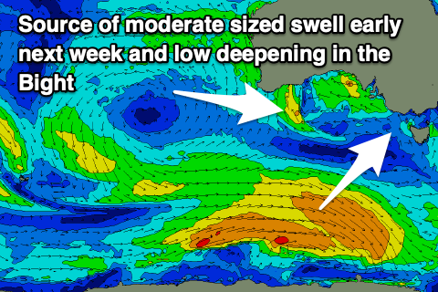
Moving into next week and the low looks to draw up a polar front early next week, bringing those strong S/SW-SW winds that should start easing into Tuesday and swing back offshore on Wednesday.
Swell wise, some localised S/SW energy is due but a stronger, moderate sized S/SW swell is due Monday afternoon/Tuesday from a healthy polar front moving through our swell window on Friday and Saturday. We'll have a closer look at this and the local winds again on Friday.
Comments
The new swell is in.