Lotsa wind, lotsa swell

South Australian Surf Forecast by Ben Matson (issued Friday 28th October)
Features of the Forecast (tl;dr)
- Average surf on Saturday
- Good surf down south Sun AM but becoming blustery
- Solid, windy waves on the Mid and metro beaches Mon thru' Fri (biggest Tues/Wed)
- Large surf developing at Victor Tues onwards biggest Wed/Thurs/Fri
- Plenty of surf next weekend
Recap
The last few days have seen poor windswells on the Mid under fresh westerlies, with slightly better conditions at Victor but still nothing worthwhile.
This weekend (Oct 29 - 30)
There’s no major changes to the weekend forecast.
Passing fronts south of the state today and tomorrow will maintain moderate swells at Victor all weekend, though Saturday will see the lingering effects of fresh westerlies and thus lower quality surface conditions. You’ll pick up OK 2-3ft waves at Middleton but it won’t be anything special.
On the Mid Coast, expect easing swells from today back to 1-2ft with moderate onshore winds maintaining the wobble.
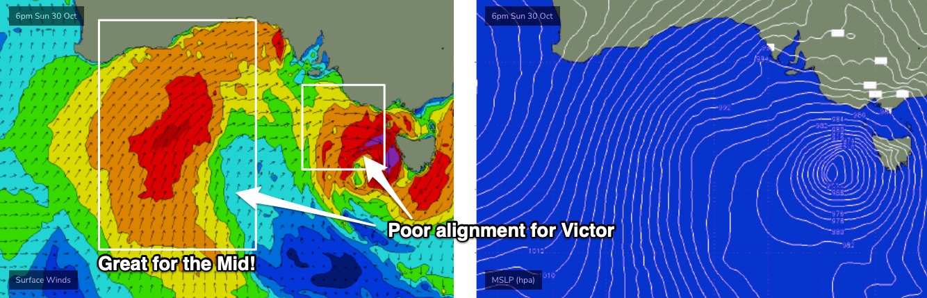
Sunday looks really interesting, with a complex low developing rapidly in the Bight, before tracking eastwards. This will see local winds swing E’ly early morning, before strengthening NE mid-morning thru early afternoon, in fact we could see 30-40kt gusts at times. The wind will trend more N’ly into the afternoon ahead of an overnight NW tending W’ly change.
As such, we may have a small window of residual surf on the Mid with early offshores, but the biggest beneficiary of this pattern will be exposed beaches at Victor - but before the wind really starts honking. So, aim for an early surf, be prepared for a slight easterly wobble at first, before freshening NE winds iron things out. But this window probably won’t last long. Size should be down to a slow 2ft+ at Middleton with bigger surf in the 3ft+ range at exposed spots.
Depending on the timing of the wind swing to the NW, Mid Coast surfers may also see some late windswells from this direction. Low quality of course.
Next week (Oct 31 onwards)
An amplifying Long Wave Trough over the southern states will drive a series of powerful fronts through the Bight throughout next week.
This is looking like a hallmark winter pattern, with four days of westerly gales generating a peak in size up to 3-5ft surf across the Mid and a couple of 2-3ft metro days as well. Tues and Wed look to see the most size in the gulf.
Of course, conditions will be terrible under the accompanying onshores, but deep down you know you really love these stormies. So, get out and amongst it.
Down south, the initial westerly storm track will restrict wave heights somewhat on Monday and maybe early Tuesday, but we’ll see the merger of several lows to the south of the state later Monday, generating S/SW gales in Victor’s southern swell window, and this will create large surf from Wednesday onwards.
Another strong polar low/front racing up from the south early in the week will maintain large surf for the rest of the week.
Wave heights should peak north of 5-6ft+ from Wednesday thru’ Friday, though there’s no clear sign of a window of favourable conditions. Friday’s probably your best bet as light variable winds kick in under a weak high pressure system, though we’ll really need a synoptic offshore to iron out the bumps and that’s not currently expected.
Looking further ahead and another series of Southern Ocean frontal systems will supply moderate swells for next weekend, though winds looks a little more fruity as a surface trough looks to influence local breezes around to the east.
Have a great weekend, see you Monday!
Comments
Love it when it’s ‘Goof’ down south.. (just teasing).
Argh.. thanks for the pickup. Missed it.
Lots bullshit
Lotsa
A lot can happen in half a day on the Mid.
Barometer is down to 988.7hPa at Neptune Island.
That's a drop by 17hPa in the last 12 hours.
Surprisingly, wind gusts have maxed out at 36kts here, though we've seen 55kts gusts at Coober Pedy Airport (!) and 48kts at Cleve Airport.
75kt gust recorded at Oodnadatta.