Fading surf with a great weekend ahead

South Australian Surf Forecast by Craig Brokensha (issued Monday April 25th)
Best Days: Selected spots tomorrow South Coast, both coasts Saturday and Sunday, Monday morning South Coast
Features of the Forecast (tl;dr)
- Easing mid-period S/SW swell tomorrow, tiny Wed and bottoming out Thu
- Moderate to fresh NE-E/NE tending fresh E/NE winds tomorrow and Wed
- Gusty N/NE tending N/NW winds Thu
- Inconsistent SW groundswell building Fri with W/NW tending SW winds
- Tiny W/SW swell on the Mid Fri
- Large W/SW groundswell building Sat, peaking later, easing slowly Sun with light morning offshore tending SW winds Sat, similar Sun
- Inconsistent W/SW groundswell building Tue PM, easing Wed with variable morning winds and afternoon sea breezes
Recap
Average conditions with an easterly chop Saturday, a bit better yesterday morning with a new mix of swells filling in. The swell was too south for the Mid Coast with tiny to flat surf seen during the weekend.
Today we've got much better conditions and a fun mix of easing SW groundswell and mid-period S/SW swell from 3ft off Middleton with micro waves on the Mid Coast.

Cleaner, head-high peaks this morning
This week and weekend (Apr 26 – May 1)
Down, down, down.
We've got small, fun surf on the swell magnets tomorrow, clean but tiny on Wednesday before the swell bottoms out on Thursday owing to the blocking effects of a strong, slow moving high pressure system edging in from the west.
Winds will hold out of the NE-E/NE tomorrow morning favouring selected spots with easing 2ft sets across Middleton/Goolwa (fresh E/NE afternoon), NE Wednesday morning before shifting E/NE into the afternoon again.
An approaching flurry of mid-latitude activity will bring fresh N/NE tending N/NW winds on Thursday with the low point in swell, with W/NW tending SW winds Friday as a weakening front clips us.
 Now, as touched on in last week's updates, we've got some solid W/SW groundswell on the way for the end of the week/weekend, but ahead of this, Thursday's possible swell from an initial front isn't on the cards any more with a tiny pulse for Friday.
Instead we should see a small, inconsistent SW groundswell building Friday, though only to 2ft across Middleton ahead of a stronger W/SW groundswell Saturday.
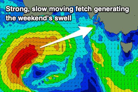
The source of the larger swell will be a strengthening polar front come mid-latitude low, firing up south-west of Western Australia Wednesday. This low will be slow moving with a fetch of W/SW gales projected nicely through our western and then south-western swell windows before it breaks down while clipping us Friday evening/Saturday morning.
 The swell will arrive through Saturday morning, building strongly into the afternoon to 3ft on the Mid Coast with Middleton pulsing to 4-5ft. Winds look favourable for both coasts in the morning and SE on the Mid, shifting SW into the afternoon with W/NW tending SW winds down South.
Sunday morning should offer similar sized waves, easing during the day along with similar light breezes.
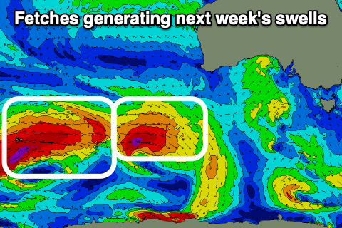
Moving into next week, it looks like we'll see light morning winds right until later in the week when SE winds kick back in along with some good, inconsistent pulses of W/SW groundswell, generated by a strong progression of storms to the south-west of Western Australia. We'll take a closer look at this Wednesday.
Comments
yewwwwww!