Poor period for the South Coast with a couple of windows for the Mid

South Australian Surf Forecast by Craig Brokensha (issued Friday July 9th)
Best Days: Mid Coast tomorrow and early Tuesday, South Coast for the desperate Tuesday
Features of the Forecast (tl;dr)
- Tiny surf for the South Coast all weekend
- Fun, easing W'ly swell for the Mid tomorrow, tiny Sun. Dawn E/NE winds tomorrow, shifting N/NE through the morning and then variable (N/NW) into the afternoon
- New W swell building Mon PM with fresh W/NW winds, easing Tue with N/NE tending N/NW winds
- Inconsistent, small W/SW groundswell building Mon PM, easing Tue
- Small new W swell late week
- Larger W/SW swell for next weekend
Recap
Wednesday's S'ly swell on the South Coast eased back from a small 2ft on the sets early yesterday, tiny into the afternoon but with favourable conditions all day. The W'ly swell seen late on the Mid Wednesday peaked overnight, easing back yesterday with tiny, wind affected waves and no quality.
Today both coasts are tiny, with clean conditions down South but a secondary pulse of W'ly swell is due very late on the Mid, with tomorrow being a better chance to get wet.
This weekend and next week (Jul 10 - 16)
Firstly looking at the South Coast, and there'll no swell of note at all through the weekend with background energy unlikely to top 1ft across Middleton, as the swell comes in too west and blocked by Kangaroo Island.
Looking at this west swell though, and a burst of W/SW winds generated under Western Australia Wednesday afternoon through yesterday morning should produce a fun increase in size tomorrow morning, with the swell possibly showing on dark today.
We should see 2ft sets across the swell magnets most of tomorrow, though expect mostly 1-2ft surf and with a favourable E/NE wind at dawn, shifting N/NE through the morning but then variable from the N/NW into the afternoon. This will be the best day of surf to target on the Mid Coast.
The South Coast will be clean but as mentioned above, tiny.
 The swell looks to be back to a tiny 1ft to maybe 1.5ft on Sunday across the Mid Coast and with less favourable, strengthening N/NE tending N/NW winds.
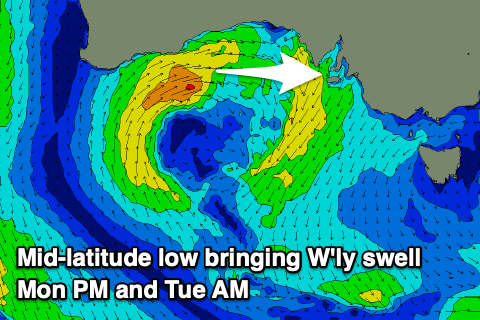
Into Monday we've got another very acute W'ly swell due on the Mid Coast with a weak, high riding mid-latitude low due to generate a fetch of W/SW winds under Western Australia and through the Bight on Sunday, weakening while moving across us Monday.
The swell will build through the afternoon, possibly tiny early but reaching 2ft+ through the afternoon along with a poor, fresh and gusty W/NW breeze. The South Coast isn't due to see any size at all from this source, with an inconsistent W/SW groundswell building to a slow 1-2ft across Middleton into the afternoon, holding Tuesday morning and then easing into the afternoon, tiny Wednesday.
Again it's worth pointing out the models are incorrectly combining swells and showing more size than expected Monday through Wednesday across the South Coast so keep your expectations accordingly low.
The Mid should ease back from 2ft on Tuesday morning and with a slight improvement in winds, N/NE early and shifting fresher N'ly through the day, tiny Wednesday with moderate to fresh N/NW winds.
Following this westerly swell there's nothing major due until another, small, weak W'ly swell arrives later in the week from another mid-latitude low drifting south-east into the Bight.
Of greater significance is what looks to be the start of a stronger mid-latitude frontal activity pushing in next Friday and into next weekend, bringing some larger though windy W/SW swell energy. We'll have a closer look at this on Monday though. Have a great weekend!