Good run for the South Coast continues

South Australian Surf Forecast by Craig Brokensha (issued Friday May 21st)
Best Days: South Coast Saturday through Tuesday, Mid Coast Sunday and more so the afternoon
Features of the Forecast (tl;dr)
- Easing surf with moderate N/NE tending variable winds Sat, new steadying SW swell for the PM
- New W/SW swell building Sun with fresh N/NE-NE winds, easing Mon with strengthening N/NE winds
- Mod-large W/SW groundswell for Tue, peaking from late morning but with strong N/NW tending NW winds
- Easing mix of windswell and groundswell Wed with strong though abating W/SW-SW winds
Recap
The surf bottomed out yesterday morning across the South Coast, clean and to 1-2ft across Middleton with the Mid Coast coming in at a tiny, windswelly 0.5-1ft.
Into the afternoon some new swell started to show down South with variable winds, creating fun waves for the late session, while today the swell has pushed in proper with clean 3-4ft waves off Middleton with a light offshore wind. The Mid Coast has remained tiny due to the swell direction but there are waves for beginners.
This weekend and next week (May 22 - 28)
Today's new mix of SW groundswell and close-range swell are now peaking and we'll see the surf easing into tomorrow, steadied into the afternoon by a reinforcing SW groundswell. This was generated by a pre-frontal fetch of W/NW gales moving under us yesterday with Middleton due to hold around 3ft on the sets, tiny on the Mid Coast and to 1ft or so.
A small W/SW swell for Sunday is also on track but the size of this swell looks a little suspect in my opinion. A more favourably aligned but small fetch of strong to gale-force W/SW winds were projected towards us and the Mid Coast looks to come in around 1-1.5ft with 2ft sets likely on favourable parts of the tide. Middleton should come in at 2-3ft.
Looking at the winds and the South Coast will fair best with a moderate N/NE breeze tomorrow morning, variable into the afternoon with fresher N/NE tending NE winds on Sunday. This fresher breeze will add small bumps and chops to the Mid, fading into the afternoon as winds go a little more east.
 Monday will see the surf easing in size and strengthening N/NE winds will favour the South Coast but it'll be blowy and tricky.
We then look at the inconsistent though strong W/SW groundswell due Tuesday with strong and trickier N/NW tending NW winds.
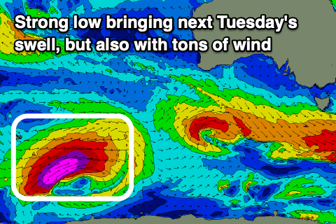
The low linked to the swell developed around the Heard Island and is generating a great fetch of storm-force W/SW winds in our far swell window while projecting slowly east-northeast.
Once south-west of WA the low will project more north-east while weakening, more into our western swell window before projecting even more north, out of our swell window.
A moderate-large W/SW groundswell is due from this low, arriving overnight Monday and peaking through Tuesday, likely from late-morning into the afternoon.
Size wise Middleton should build to 4-5ft with the odd bigger one likely from Day St onwards, with the Mid Coast pushing to 3ft+ through the day. Unfortunately the remnants of the low sill strengthen in the Bight, bringing those strong and tricky winds with a junky NW windswell combining with the groundswell on the Mid Coast.
Wednesday will see the groundswell easing with strong W/SW winds in the wake of the low, along with some easing W/SW-SW windswell. The Mid should ease from 3ft with 4-5ft sets but with those onshore winds. More on this Monday. Have a great weekend!