Windy weekend ahead

South Australian Forecast by Craig Brokensha (issued Friday 3rd December)
Best Days: Keen surfers both coasts Sunday, but you'll have to deal with the wind, Mid Coat Tuesday, South Coast Wednesday morning
Recap
The Mid Coast offered great waves all day yesterday with fairly consistent 2ft sets, a bit bigger with the late afternoon push and the South Coast was still solid and lumpy, best suited to the breaks around Victor in the morning, Middleton into the afternoon as it eased more.
Today the Mid Coast was still offering 1-2ft sets at dawn but it's since dropped back in size and with bumpy conditions. The South Coast was a little lumpy early but has cleaned up with a fresher offshore wind, easing from 2-3ft across Middleton. With the east in the wind though, eastern ends of beaches are best.
This week and weekend (Dec 4 - 11)
The swell from the last couple of days will continue to bottom out into tomorrow morning, leaving 1-2ft waves across Middleton, with the odd bigger one on the magnets. Conditions will become windy and blowy with a strengthening N/NE offshore, swinging W/NW late morning and becoming stronger into the afternoon. So all in all it looks a lay day.
 This change will see a building, stormy W/SW windswell on the Mid Coast, kicking to a consistent 3ft by late.
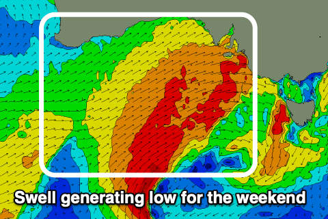
This strong cold front is attached to a deepening low that's currently forming south of Western Australia.
This low now looks to sit a touch further south when strongest tomorrow and this will reduce the expected size on the Mid Coast a touch, but we're talking from 3-4ft down to 3ft+.
As the low forms, a great fetch of W/SW gales will be projected towards us, generating a mix of moderate to large sized W/SW swell (mid-period and groundswell energy).
The South Coast will build later tomorrow but peak Sunday to the 4ft range across Middleton, and protected spots will be the pick with a strong, persistent W'ly wind.
The Mid Coast should start easing in size Monday, but the South Coast will see an increase in new mid-period S/SW swell owing to the backside of the low projecting strong SW winds up and into the region. Also a reinforcing S'ly swell is due later Tuesday and Wednesday morning from strong to gale-force S'ly winds generated just before the low moves east under Tasmania.
Unfortunately strong, dawn W'ly winds are due to swing SW by mid-morning, creating choppy conditions as the swell increases to the 4-5ft range off Middleton. The Mid Coast will hold around 2-3ft all day but also be choppy.
Tuesday looks poor on the South Coast with strong S/SW winds along with moderate amounts of S/SW swell, while we may see more variable winds on Wednesday morning with some decent size left in the mix. The Mid will be a bit cleaner though still remain bumpy Tuesday with easing 2ft surf, tiny and clean Wednesday.
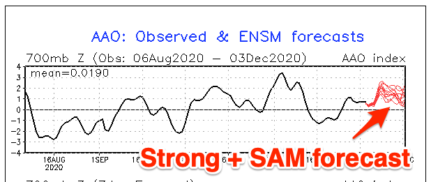 Longer term, a high will move in slowly from the west next week, keeping winds S-SE and one final strong polar front will fire up in our swell window before things go quiet. A moderate sized S/SW swell is on the cards for late week, but beyond this, a positive Southern Annular Mode (SAM) event will see the westerly storm track contract to the poles, and weaken.
This will see the Southern Ocean become inactive, with nothing too significant at all on the cards for next week besides junky amounts of S/SE windswell. More on this Monday. Have a great weekend!