Tricky period with smaller west swells on the way

South Australian Forecast by Craig Brokensha (issued Monday 9th November)
Best Days: Today down South, tomorrow morning down South, keen surfers both coasts Thursday and Friday, Saturday morning South Coast
Recap
Tiny, clean waves on the Mid Coast all weekend for beginners, average down South with bumpy 2-3ft surf Saturday, bigger yesterday with workable easterly winds for the keen.
Today conditions are much cleaner down South and with plenty of swell left in the mix, dropping back from the 3ft range.
This week and weekend (Nov 10 - 15)
Make the most of the current, clean waves as we'll see the surf dropping back quite a bit tomorrow and remaining small on the South Coast as the surf builds out of the west.
Stronger offshore N/NE winds are due tomorrow, though not strong enough to blow out the surf but the swell will be small, slow and easing from 2ft on the sets across Middleton.
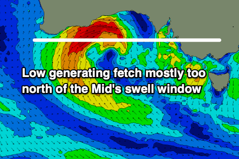 Looking to our west, a deepening mid-latitude low south of WA is now forecast to sit a bit too far north to generate the expected 3-4ft last Friday, and instead we've got a downgrade in the expected size across the Mid Coast.
The Eyre Peninsula will receive the bulk of the size with a fetch of W/SW gales now due to be generated high in the Bight, north of the Mid Coast's main swell window until Wednesday when it weakens and dips south-east.
What we're now expected to see is an increase in W/NW windswell late Wednesday only to 2ft or so as morning N/NE winds strengthen and swing W/NW.
Thursday will see the most size with a mix of windswell, mid-period swell and groundswell along with strong though easing W/NW tending W/SW winds. We may see winds hold out of the W down South but we'll review this Wednesday.
The Mid Coast should offer choppy 3ft waves with the South Coast struggling to see much size at all due to the shadowing effect of Kangaroo Island. Middleton looks to vary from 2ft+ off the Point to a bigger 3ft at Goolwa, easing from a similar size Friday.
Winds look OK for protected spots and W/NW in the morning down South Thursday, unfortunately lingering out of the W/SW on the Mid as the swell eases, dropping from 2ft.
Saturday will see winds go offshore for both regions out of the NE but the surf looks tiny on the Mid Coast and easing from a small 2ft across Middleton.
 Longer term there isn't anything too significant on the cards as an upper level blocking pattern sets up across Victoria. This will see frontal systems aimed towards Western Australia before dipping south-east through our swell window. We'll see distant and inconsistent W/SW groundswells generated in the southern Indian Ocean and one such is due Sunday.
This will be produced by a strong though distant low forming north-east of the Heard Island region, generating a significant fetch of gale to severe-gale W/SW winds.
The swell should favour the Mid Coast and provide inconsistent though fun 1-2ft sets on the favourable parts of the tide Sunday though a westerly change looks to move through with the arrival of the swell. The South Coast looks a touch cleaner but small and only to 2ft or so across Middleton. More on this Wednesday.