Lots of surf days ahead

South Australian Surf Forecast by Craig Brokensha (issued Friday 9th October)
Best Days: Mid Coast tomorrow, South Coast tomorrow morning, Sunday down South, Monday, Tuesday Mid Coast, Wednesday (afternoon on the Mid Coast)
Recap
A choppy and building windswell on the Mid Coast yesterday with OK conditions in protected spots down South through the morning, onshore into the afternoon.
Today conditions are best in protected spots down South again with a bit less wind and S/SW swell to 2-3ft, bumpy and to 1-1.5ft on the Mid. A new W/SW groundswell is due this afternoon providing 1-2ft sets on the Mid Coast as winds shift N/NE late. The South Coast should build to an inconsistent 3ft with onshore winds tending variable and even N/NW late, so keep an eye on things.
This weekend and next week (Oct 10 - 16)
This afternoon’s building W/SW groundswell should peak tomorrow across both coasts with the size coming in more around 2ft on the Mid Coast, but inconsistent. The South Coast should also see a touch more size with surf mostly to 3ft off Middleton, with the rare bigger set.
It’ll be a bit bumpy on the Mid Coast with a N/NE breeze, shifting NW through the morning and then W/SW into the afternoon though without much strength. With this we’ll likely see winds shift S/SE on dark. The South Coast should be great with a N/NW offshore, giving into a late morning W/SW tending S/SW change.
Sunday looks smaller across all coasts as we fall in between swells, with the Mid likely dropping to 1-1.5ft, 2ft to occasionally 3ft across Middleton.
Conditions Sunday look great with local offshore winds from the north-eastern quadrant, tending variable on the Mid and E/SE down South into the afternoon.
We then look at the strong, large W/SW-SW groundswells due through early next week.
The first swell which may be seen right on dark Sunday is due to fill in overnight and peak Monday morning. This has been and is still being generated by a great frontal progression that formed around the Heard Island on Wednesday. A fetch of initial gale to severe-gale winds were produced, weakening slightly while projecting towards Western Australia. The storm has now broken down south-southwest of WA and we’ll see the inconsistent W/SW groundswell making its way towards us on the weekend.
 The peak on Monday should provide inconsistent 4-5ft+ sets from Middleton to Goolwa, while the Mid Coast should see 2ft to occasionally 3ft sets on the favourable parts of the tide. Winds look great as well with fresh N/NE tending N/NW winds down South, dawn NE tending N/NE winds on the Mid and then N’ly at times, back to the N/NE later.
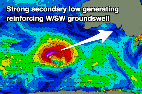
A slightly larger, longer-period, reinforcing W/SW groundswell will fill in Tuesday, generated by a tighter and more intense low pushing towards us over the coming days from just north of the Heard Island region.
Severe-gale to storm-force W/SW winds are forecast to move through our swell window, on top of an active sea state we’ll see strong and powerful surf into Tuesday.
 Middleton should see strong 4-6ft sets with a continuation of 2ft to occasionally 3ft waves on the Mid Coast and winds look best for the Mid Coast with a variable breeze through the morning, possibly remaining so through the afternoon. The South Coast may see variable winds early, but will quickly shift S’ly mid-morning.
Wednesday will see the W/SW groundswell easing but swinging a touch more SW in direction owing to the swell producing low moving more into our south-western swell window as it weakens. Winds should improve down South and swing N’ly, creating bumps on the Mid Coast, possibly variable into the afternoon again.
On Thursday it looks like we’ll see a trough proper move through bringing a stronger S’ly change as the SW swell eases. We’ll confirm this and a follow up S/SW groundswell for next weekend on Monday though. Have a great weekend!
Comments
The U-Turns and Trig Cam has been through a bit from the looks of it.
We'll get 'em cleaned ASAP.
Cheers!
Ben I imagine the job is like being a meteorologist and a property manager, all rolled into one.
one of those days when models said w and wind said ne
Doesn't anyone surf any more? Fun lil' peelers on the Mid, and there's no-one in the water.

