Increasing swell activity with decent winds

South Australian Forecast by Craig Brokensha (issued Wednesday 7th October)
Best Days: Later Friday both coasts, Saturday morning both coasts, Sunday South Coast, Monday, Tuesday, Wednesday
Recap
Poor though sizey waves across the South Coast yesterday, building further into the afternoon, but best on the Mid Coast with clean 1-2ft waves all day.
Today the swell has backed off on the Mid with clean, tiny 1ft waves, improving a little down South but still a bit all over the place with light E/NE winds and easing 3-4ft sets.
This week and next (Oct 8 - 16)
Moving into tomorrow we'll see a broad low drifting south-east across Victoria while deepening, bringing a westerly change and strong W/SW winds through the gulf, tending W/NW down South in the morning before shifting back to the W/SW around midday.
The Mid will likely see a junky 1-2ft of windswell building through the day with the South Coast dropping back to 2-3ft, but holding into the afternoon as a local SW windswell develops from the backside of the low.
Come Friday winds are due to revert back to the W/NW-NW in the morning (moderate in strength) and possibly swinging more N/NW into the late afternoon and even NE in the Mid.
Size wise, Friday morning looks small and weak with a S/SW windswell dropping on the South Coast and W/SW windswell on the Mid Coast ahead of our first, inconsistent pulse of W/SW groundswell into the afternoon.
This first inconsistent W/SW groundswell will be the smallest of the coming pulses due over the coming period and into next week, generated by a healthy and broad though not overly strong progression, south-west of WA the last few days.
A late pulse in size to 1-2ft is expected on the Mid Coast, with those improving winds while the South Coast should build to 3ft across Middleton, but with long waits for sets.
A peak is due Saturday morning with a possibly the odd bigger set showing across the Middleton stretch, easing through the day with surf coming in around a better 2ft on the Mid. Winds look OK early and light N'ly on the Mid, but swinging more W/NW through the morning, with W/NW winds down South ahead of a SW change linked to a weak trough.
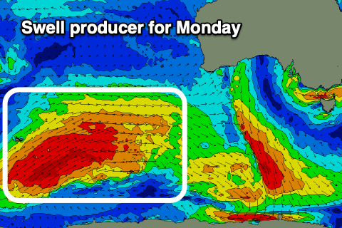 Sunday will be smaller as Saturday's swell eases and we reach a low point ahead of a moderate to large, long-period W/SW groundswell arriving on dark, peaking Monday morning.
The swell will be generated by a more significant, broader and closer projecting fetch of W/SW gales moving through our swell window. The storm is currently forming in the Heard Island region and will project on the back of the active sea state generated by the front linked to Saturday's swell.
It'll weaken south-west of WA early Friday, with the swell travelling towards us on the weekend, arriving very late Sunday and peaking Monday. Middleton should see strong 4-5ft+ sets with the Mid Coast coming in at 2ft to occasionally 3ft on the favourable parts of the tide.
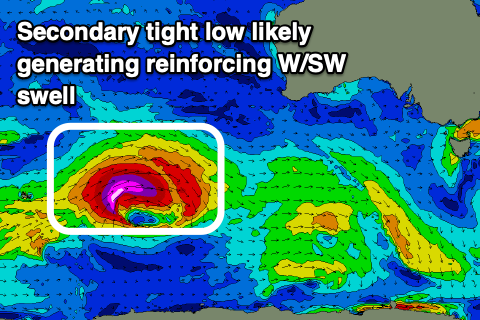 Winds are tricky at the moment as the models diverge regarding a deepening surface trough in our far west but it looks like we'll see N/NE-NE breezes Monday, similar Tuesday as a secondary, large reinforcing W/SW groundswell fills in.
This secondary swell looks to be generated by a tight, strong low moving in behind the progression linked to Monday's swell, but we'll have a closer look at this on Friday.
Comments
Teaser, teaser, teaser.

What! And no one out???
Hmmmm, weak 1ft light onshore small runners, definitely not worth loosing a foot or leg over though Tim? Hey Wilko! JESUS, it's got us all thinking of those strange splashing, water upwelling moments that we all just brushed off..... I guess it'll just happen if it happens? Part of being an ocean adict I guess?