Small to tiny, before building later week

South Australian Forecast by Craig Brokensha (issued Monday 28th September)
Best Days: South Coast magnets tomorrow, both coasts Thursday afternoon and Friday (best down South), Saturday morning South Coast
Recap
Early light winds and lumpy 2ft waves for the keen across the Mid Coast on Saturday morning, poor and choppy to 3-4ft on the South Coast.
The swell dropped right out into Sunday on the Mid Coast while the South Coast offered more variable breezes and cleaner, peaky 2-3ft waves.
A new mid-period S/SW swell arrived late in the day and has kept the surf up around 3ft off Middleton with an offshore wind, clean but flat on the Mid.
This week and weekend (Sep 29 – Oct 4)
Today's mid-period S/SW swell will ease into tomorrow and we'll be left looking at smaller 2ft sets left across Middleton, not too much bigger across the magnets owing to the southerly direction.
Winds will be good for most locations with a fresh N/NE tending N/NW breeze, easing later afternoon.
Wednesday will be a lay day with tiny leftover levels of swell and W/NW-NW winds.
We then look at the mid-latitude and Southern Ocean frontal activity moving in through the week, passing through and just south of the Bight over the coming days.
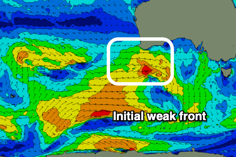 Initially the strength and alignment of this activity isn't too flash, with a small low generating a burst of strong W/SW winds this evening and tomorrow,, then tracking east-southeast and under us Wednesday.
A small mid-period W/SW swell should be seen Thursday afternoon from this source, building to 2ft on the Mid Coast and 2-3ft across Middleton along with N/NW winds on the South Coast and W/SW tending N/NW winds on the Mid. While bumpy it should still be fun on the Mid into the afternoon.
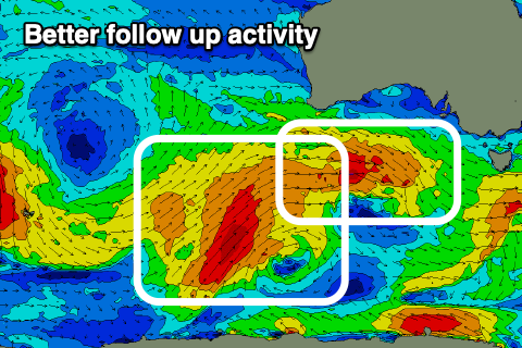
A secondary stronger front generating pre-frontal W/NW gales will track unfavourably south-east and be aimed away from us, with only some limited swell due off this source Friday afternoon.
Friday morning looks to come in around the same size as Thursday afternoon, with the new swell kicking to a stronger 3ft down South, if not for the odd bigger one across Middleton, and holding 1-2ft on the Mid Coast.
 Winds will remain good and offshore out of the N/NW-N all day, tending N/NE on the Mid, but it'll be best down South.
Now, following Thursday/Friday's front a drawn out and more southerly positioned frontal system is forecast to generate a healthy fetch of strong to gale-force W/SW winds, producing a swell from a touch better direction.
This is due Sunday, but before this we'll likely see the state holding a similar size to Friday on Saturday with stronger N'ly winds ahead of a S'ly change as a deepening inland trough moves slowly in across the state.
Following this on Sunday conditions look poor with fresh S/SE winds and easing levels of swell, but we'll confirm this on Wednesday.