More wind and cold to come

South Australian Forecast by Craig Brokensha (issued Wednesday 23rd September)
Best Days: Protected spots down South tomorrow, Sunday and Monday down South
Recap
A large, choppy increase in W'ly swell to 3-4ft across the Mid Coast yesterday, with Kangaroo Island blocking a lot of the energy down South, resulting in choppy waves ranging from 1-2ft at Middleton, more towards 3ft at Goolwa.
Today the swell has shifted a little more south in direction with some better size off Middleton Point and a drop in winds, still poor and choppy to 2-3ft on the Mid Coast.
This week and weekend (Sep 24 – 27)
The strong though weakening mid-latitude low linked to the windy swells the last couple of days is now clearing to the east, but we're seeing a secondary cold shot of air pushing up and into us from polar latitudes.
This will bring poor conditions from tomorrow afternoon along with weak windswelly waves, mixed in with mid-period southerly energy.
Tomorrow morning we should see a W/NW breeze down South along with a fun, easing S/SW swell (generated from the backside of the low), with 2-3ft sets across Middleton, dropping into the afternoon. The Mid Coast will drop further from 1ft to maybe 2ft.
 Winds should hold out of the W/NW until early afternoon, then shifting W/SW before giving into stronger S/SW winds on Friday.
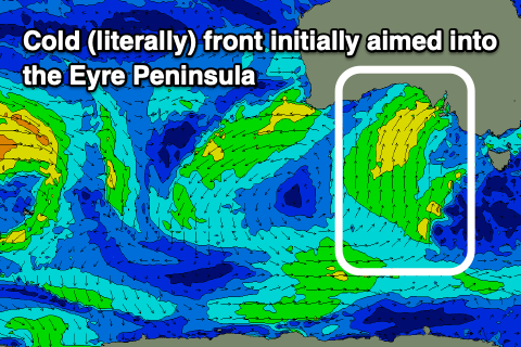
Along with the change will be some building windswell and mid-period S/SW energy, initially aimed into the Eyre Peninsula but becoming better aligned for the South Coast through the day Friday, followed a more polar fetch Friday evening and Saturday.
The Mid Coast will see an increase in SW swell on Friday from the initial fetch, likely to a choppy 2ft+, fading Saturday from 1-1.5ft.
The South Coast looks to build Friday to 4ft+, easing from the 3-4ft range on Saturday but with fresh S/SW-SW winds.
We should see more variable winds develop on Sunday morning, with small levels of leftover S/SW swell, building a little into the afternoon from the polar fetch of S/SW winds. Middleton looks to be around 2ft in the morning, building to 3ft later in the day, then easing from 2-3ft Monday morning.
Afternoon sea breezes are likely Sunday, with Monday seeing NE winds with the easing S/SW energy. Following this winds are due to swing more offshore out of the N/NE on Tuesday and Wednesday but the swell will be tiny.
Longer term there's nothing too major on the cards until later Friday and next weekend when we may see some OK mid-period SW swell for the state. More on this Friday.