Average end to the week, improving weekend

South Australian Forecast by Craig Brokensha (issued Wednesday 16th September)
Best Days: Today down South, Saturday selected spots on the South Coast, Sunday South Coast
Recap
Great waves at dawn yesterday with a clean, good, consistent 2ft+ wave on the Mid Coast swell magnets, slowing through the day before kicking again with the tide and a weak onshore wind. The South Coast was solid and to 4-5ft off Middleton with light winds and generally clean conditions, straighter this morning and still 3-5ft.
The swell has started to ease across the Mid Coast back to 1-1.5ft this morning with a bumpy northerly wind.

Early bird and all, yesterday morning
This week and weekend (Sep 17 – 20)
A shallow change is due early this evening as a trough moves in from the west, followed by a high and this will shift winds around to the E/SE-SE tomorrow but with strength.
Our current SW groundswell will ease further and out of a more S/SW direction tomorrow but with those winds, conditions will be poor down South. The Mid Coast will be clean though tiny and to 1ft max.
Moving into Friday winds should swing around to the E/NE but they'll still be fresh so conditions across Middleton will be junky and bumpy, better towards Goolwa and other spots that handle the easterly. Size wise the surf looks to be at a low point but still 2ft+ across Middleton, bigger on the more exposed beaches and tiny on the Mid Coast.
Our new S/SW groundswell for Saturday is on track, as are the favourable conditions and winds.
A strengthening polar fetch of elongated W/NW tending W'ly gales will push in and under the country today and tomorrow. Following this another low drifting south-east from the Indian Ocean will strengthen but the fetch will be NW aimed away from us and not ideal for swell production.
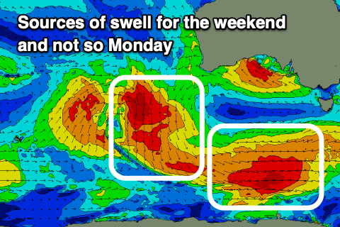 The fetch today and tomorrow should produce a good pulse of S/SW groundswell for Saturday, with a peak likely into the afternoon to 3ft to occasionally 4ft across the Middleton stretch, with a bit more size at the exposed beaches. The Mid will be tiny to flat.
Winds should hold out of the NE and be a bit gusty as a broad mid-latitude low starts moving in from the west, so target those north-east friendly breaks.
Conditions look even better Sunday as the S/SW groundswell eases from the 3ft range and winds hold out of the N/NW, fresh into the afternoon.
Next week onwards (Sep 21 onwards)
The mid-latitude low mentioned above will start moving in from the west through the weekend and as it does so it's expected to strengthen in or south of the Bight. The models are converging on this scenario and as a result we're due to see a moderate to large, stormy W/SW swell event for the Mid Coast early next week, with smaller, cleaner waves down South later week as the low clears. More on this Friday though.