Make the most of a coming W/SW swell

South Australian Forecast by Craig Brokensha (issued Monday 22nd June)
Best Days: Desperate surfers Wednesday morning South Coast, both coasts Friday, Saturday South Coast
Recap
A tiny and clean start to the weekend on the South Coast, bigger yesterday but poor and onshore. The Mid Coast started around a choppy 1ft Saturday and built through the day, sloppy and average yesterday and to 2-3ft for the desperate.
Today conditions are poor and choppy across both coasts with the swell kicking back to 2-3ft on the Mid Coast, a sloppy and choppy 2-3ft down South.
This week and weekend (Jun 23 - 28)
The coming week and actually fortnight are looking fairly average for our region apart from a couple of days.
An upper level blocking pattern will set in later this week, which following the coming W/SW swell event will block any major swell generating systems resulting in small to tiny surf but with favourable winds.
Coming back to our current setup, and a broad mid-latitude low that stalled south-west of us on the weekend and influenced our weather and swell window has now moved east and we're seeing the western flank of the low generating strong onshore S/SW winds.
We'll see the low continue east tomorrow but conditions will remain poor with a moderate to fresh but easing S/SW tending SW breeze and easing mix of small, average swells.
Wednesday should become cleaner with a light morning NE breeze on the Mid, NW down South but the surf will be small to tiny. The models are showing a new W/SW groundswell but the source of this swell was a very distant low south-east of Madagascar and no size is due. A weaker S/SE windswell to 2ft is the more dominant source of swell down South, with the Mid possibly seeing 1ft sets.
 This swell will fade Thursday with W/NW tending SW winds, leaving no quality surfing options.
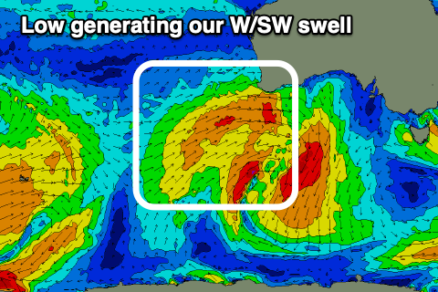
Come Friday though a new mid-period W/SW swell is due, produced by a mid-latitude low that's currently moving in towards WA. It's north of our swell window but we'll see it dip south and project a great fetch of strong W/SW winds through our western swell window tomorrow while stalling. The low will then weaken slowly while tracking east-southeast and then under us Thursday.
A moderate sized W/SW swell should be seen, possibly showing on dark Thursday but peaking Friday to 2-3ft on the swell magnets across the Mid Coast, and reaching 3ft off Middleton. A bonus of the system dipping east-southeast and away from us is that winds will be favourable and locally offshore Friday morning, variable into the afternoon.
Saturday will then be best across the South Coast as the swell eases from 2-3ft off Middleton with N/NE offshores, fading from a bumpy 2ft on the Mid Coast.
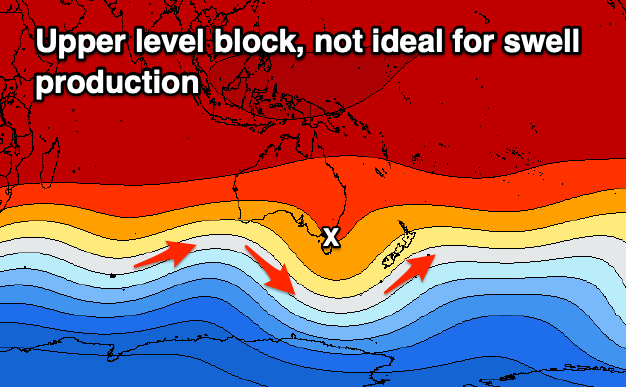
From Sunday the effects of the upper level block will take hold and we're looking at a tiny run of swell with winds from the north-eastern quadrant through all next week. There's hope for some new W/SW swell late week, but more on this Wednesday and Friday.