Continuation of westerly swells though windy

South Australian Forecast by Craig Brokensha (issued Friday 29th May)
Best Days: South Coast all weekend, South Coast Tuesday morning
Recap
Wednesday's strong pulse of W'ly groundswell easing back to 2-3ft yesterday on the Mid Coast with workable winds all day for keen surfers, still 2ft to occasionally 3ft early this morning with OK conditions before winds picked up. The South Coast has offered great conditions with 3ft of swell off Middleton yesterday, a little smaller today and back to 2-3ft.
This weekend and next week (May 30 – Jun 5)
We've got plenty more W/SW swell on the way from continued mid-latitude frontal activity up, into and then under WA.
Winds will become less favourable for the Mid Coast though as one of the swell producing fronts moves in through the Bight.
Looking at tomorrow and we're expected to see the swell easing back a little more as we fall in between swells, 2ft off Middleton and 1-2ft on the Mid Coast. Strong N/NE tending N/NW winds will create tricky conditions down South, while kicking up a poor quality N/NW windswell to 2ft+ later in the day on the Mid Coast.
A new inconsistent W/SW groundswell should build Sunday, generated by W/SW gales pushing towards WA yesterday and into the evening, but this will be overridden by a locally generated mid-period W/SW swell as the frontal progression pushes through the Bight tomorrow.
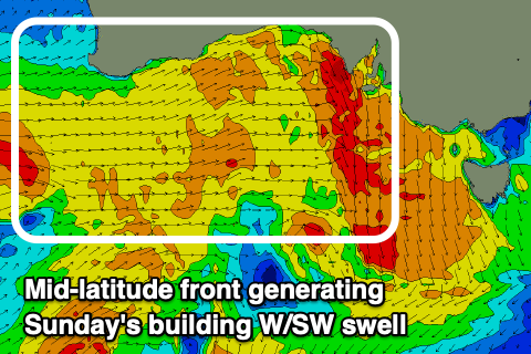 Strong W/SW winds projected towards us under WA this evening and tomorrow should kick up 2ft+ of W/SW swell for Sunday on the Mid, while the direction isn't great for the South Coast with waves to 2-3ft off Middleton, more so 3ft at Goolwa.
NW winds will strengthen through Sunday, favouring the South Coast and producing choppy waves on the Mid Coast. Come Monday, a small embedded low forming in the frontal progression is expected to move in from the west and stall, bringing strong S/SW winds around or just after dawn.
A stormy increase in swell is expected to develop on the Mid Coast to 3ft, kicking to 3-4ft on the South Coast. The speed of the low is still up fro grabs but it looks fast and winds should ease and tend back to the W/NW for Tuesday morning with a mix of easing swells.
Into the middle to end of the week a good new S/SW groundswell is on the cards from a strong polar low developing under the country and winds look favourable for the South Coast, but more on this Monday. Have a great weekend!