Lots of west swell on the way

South Australian Forecast by Craig Brokensha (issued Monday 25th May)
Best Days: South Coast magnets tomorrow morning, Mid Coast later Wednesday, Mid Coast Thursday and Friday, South Coast later Wednesday through Sunday
Recap
Friday's large waves continued into Saturday but with poor onshore winds, easing back into Sunday but with conditions remaining bumpy and onshore.
The Mid Coast saw cleaner conditions but tiny waves all weekend.
Today has cleaned up nicely with a new SW groundswell from yesterday afternoon keeping Middleton around 2-3ft, though tiny on the Mid Coast.
This week and weekend (May 26 - 31)
Tomorrow will be great again conditions wise down South, if a little blowy early with fresh and gusty N/NE winds, shifting more N'ly into the afternoon along with small fading 2ft sets across Middleton, tiny into the afternoon.
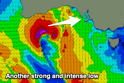 Moving into Wednesday and we've got our good and acute new W'ly groundswell on the way, generated by the remnants of Tropical Cyclone Mangga in the tropical Indian Ocean, being absorbed into the westerly storm track off WA and forming into a deep and powerful low.
The low is strongest while out of our swell window, but as it drifts south this afternoon and evening we'll see a tight fetch of severe-gale to storm-force W/SW winds aimed through the Mid Coast's swell window, weakening as it pushes east tomorrow.
A large W'ly groundswell will result that now looks too west to provide any decent size across the South Coast owing to the blocking effects of Kangaroo Island.
We should see the swell build Wednesday, peaking into the afternoon with strong 3ft sets (if not the odd bigger one on the magnets), possibly hitting 2ft+ later in the day across Middleton, tiny in the morning.
 Winds in the morning won't be too favourable and fresh out of the N tending N/NW, but we should see winds easing out of the NW later in the day with the peaking swell, creating improving conditions for the keen.
The swell will then ease into Thursday from 2ft to possibly 3ft with light N/NE winds in the morning, NW into the afternoon and then possibly variable later.
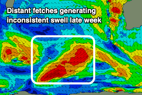
The South Coast looks to remain small and to 2ft or so off Middleton while later in the day some new inconsistent W/SW-SW groundswell is due.
This swell, discussed late last week has been generated by very distant but strong back to back polar storms west, south and east of the Heard Island region over the weekend. The Mid Coast isn't likely to drop below 1-2ft on the favourable parts of the tide with the help of weak mid-latitude fronts pushing in and under WA through tomorrow and Wednesday, while the South Coast should build to 3ft Thursday afternoon off Middleton, coming in a similar size and easing Friday.
Winds will remain favourable as well and from the N/NE tending N/NW on Friday, stronger N/NE tending N/NW Saturday with an approaching front.
A small kick in W'ly groundswell is likely on Saturday from a tight and short-lived mid-latitude low firing up south-west of WA on Wednesday, keeping the Mid around 2ft on the sets Saturday, small and to 2ft+ down South.
The approaching front looks to generate some additional though tricky W/SW groundswell for Sunday/Monday but we'll have to have a closer look at this on Wednesday as the embedded systems linked to this are tricky to get a handle on.