Easing surf, windy, stormy weekend

South Australian Forecast by Craig Brokensha (issued Wednesday 1st April)
Best Days: Tomorrow morning South Coast, Friday morning South Coast, Sunday protected spots down South, Monday morning both coasts
Recap
Monday afternoon's strong kick in W/SW swell dropped back to 2ft or so yesterday morning on the Mid but again kicked to a good 2-3ft on the incoming tide under variable winds.
The South Coast also built through the day with the arrival of a strong new SW groundswell with sets to 4-5ft off Middleton into the afternoon with weak sea breezes.
Today the swell has eased a touch across both regions though Middleton is still an easy 4ft and nice and lined up, 1ft to occasionally 2ft on the Mid Coast.
This week and weekend (Apr 2 - 5)
We'll see the surf easing over the coming days ahead of a windy weekend and increase in W/SW and SW swells.
The size will fade further on the Mid Coast tomorrow, tiny and to 1ft mostly, but the favourable parts of the tide are still expected to see sets to 1.5ft.
A reinforcing W/SW groundswell due this afternoon will soften the easing trend, produced by a good fetch of W'ly gales under WA at the start of the week, while weaker W/SW-SW fetches trailing this will keep the coast active through Friday.
Size wise we should see Middleton dropping back to 3ft+ tomorrow, dropping further from 3ft on the sets Friday morning, with the Mid dropping back to 0.5-1ft.
Locally winds tomorrow look favourable and light from the E/NE-NE down South, offshore on the Mid ahead of sea breezes, great for exposed beaches down South Friday morning with a strengthening N/NW tending W/NW breeze.
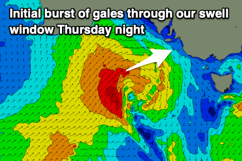 This strengthening wind will be associated with a deepening mid-latitude low, feeding off an upper cold pool linked to a fast moving node of the Long Wave Trough moving across us.
As this low forms tomorrow afternoon just west of the Bight, a fetch of strong W/SW winds will be generated in our western swell window, reaching gale-force for a brief period while moving east and more through our south-western swell window.
We'll likely see a late afternoon increase in windswell on the Mid Coast Friday, with Saturday seeing a mix of mid-period and stormy W/SW swell to 3ft, while the South Coast should build through the day Saturday from 3ft or so to 4-5ft into the afternoon owing to a secondary front pushing up and into the coast.
Winds will accordingly be strong from the W-W/SW on Saturday morning, shifting W/SW proper later morning, creating poor conditions.
Sunday looks more favourable for protected spots down South as winds shift back to the W/NW, quite gusty, with poor conditions on the Mid.
Size wise, 4-5ft surf looks to continue down South, 2ft+ and choppy on the Mid.
A high is expected to move in behind the low and fronts Sunday evening, bringing more variable winds into Monday though likely taking a S/SE tendency with easing surf from what looks to be at this stage 3-5ft on the South Coast and 1-2ft on the Mid.
We'll have a clearer idea on the timing, sizes and local winds with the weekend's swells come Friday so check back then for the latest.
Comments
I love a good mid stormy.