Fun run of waves for both regions

South Australian Forecast by Craig Brokensha (issued Monday 28th October)
Best Days: Both coasts tomorrow morning, Wednesday South Coast and swell magnets down South Thursday morning, South Coast Saturday morning and both coasts Sunday morning
Recap
Poor onshore and sizey waves on the Mid Coast Saturday, settling down a little yesterday with lighter onshore winds and 2-3ft sets. The South Coast was poor, windy and building Saturday, much better yesterday with a more organised swell to 2-3t off Middleton and lighter W/NW winds.
This morning the South Coast was cleaner again along with the swell hanging in at 2-3ft, with the Mid 1-1.5ft, but a new long-period W/SW groundswell is filled in providing better 2ft sets (below) on the Mid with light onshore winds.

This week and weekend (Oct 29 – Nov 3)
It's good to be back again, though coming in a little cold in respect to the long-range and inconsistent W/SW groundswell due across the state over the coming days.
This swell provided large pumping surf in WA yesterday and is now filling in across our region with the Mid due to reach 2ft+ later today, with punchy 3ft sets off Middleton.
This swell is expected to hold tomorrow around a similar size, 2ft+ on the favourable parts of the tide across the Mid Coast and 3ft off Middleton before easing off through Wednesday.
Conditions are looking great for both regions tomorrow with an early N/NE offshore down South, NE on the Mid, freshening and swinging more N/NW ahead of a late afternoon change which will be quite shallow and allow for variable and favourable winds across both coasts Wednesday, evening holding from the N'th most of the day as a cold front moves in.
The surf will continue to fade into Thursday with stronger N tending N/NW winds, so hit up the South Coast swell magnets for a wave.
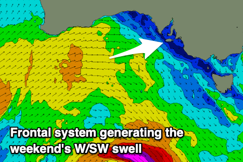
Into Friday a new inconsistent W/SW groundswell is due, generated by a tight and strong but distant low that's developed around the Heard Island region. A fetch of severe-gale to storm-force W/SW winds are being produced, with the low due to weaken while approaching the south-west of WA this evening, breaking down through the day.
The swell is due to arrive Friday and build to 2ft+ across Middleton by late afternoon with tiny 1-1.5ft waves on the Mid Coast.
 Conditions will be clean early with a fresh N/NE offshore but a strong W/SW-SW change is due into the afternoon as the new swell fills in.
This change will be associated with a broad but relatively weak and dissolving mid-latitude frontal progression moving in from the west later week. While looking good on the synoptic charts, the progression will be muddled and weak, with a broad fetch of strong W/SW winds forecast to be aimed through our western swell window under WA and through the Bight late this week dipping slowly south-east through Saturday before possibly being followed by a secondary weaker front.
The swell will be mid-period and west in nature, ideal for the Mid Coast and filling in Saturday, building to 2ft+ later and peaking Sunday to 2-3ft, while the South Coast looks to remain on the small side and to 2-3ft across Middleton.
Winds are still a little unsure but we may see early light NW breezes Saturday morning before swinging SW and then variable NE winds Sunday morning favouring both coasts, but we'll have a closer look at this Wednesday.
Comments
Swell has kicked with the tide..