Tiny ahead of large back to back swells from late week

South Australian Forecast by Craig Brokensha (issued Monday 8th July)
Best Days: Protected spots South Coast Thursday morning, Friday morning, Saturday experienced and keen surfers, Sunday morning, later Monday and Tuesday morning
Recap
Good waves on the South Coast swell magnets over the weekend, tiny and ideal for beginners at Middleton. The Mid Coast was flat Saturday but our new W/SW groundswell for Sunday came in at 1-1.5ft, but pulsed above expectations into the afternoon with sets to 2-3ft across the magnets.
This morning the swell was back to 1-2ft on the Mid and bumpy, with Middleton seeing a touch more size, best at Waits and Parsons.
Today’s Forecaster Notes are brought to you by Rip Curl
This week and weekend (Jul 9 – 14)
Tomorrow will be a lay day as today's swells drop in size with a moderate to fresh N/NW tending NW breeze. The Mid Coast will be tiny and bumpy with clean but tiny surf off Middleton, OK at Waits for desperate surfers to 2ft on the sets.
Wednesday will be tiny again with fresher NW breeze, strengthening from the W/NW into the afternoon with an approaching front. This will kick up a building windswell on the Mid Coast, likely reaching 2-3ft by dark, with Thursday seeing even more size to a stormy 3ft to occasionally 4ft as a secondary front pushes in and across us.
These fronts and a couple of stronger ones to follow will be under the influence of a strengthening node of the Long Wave Trough moving in across the south-east of the country.
Middleton should also increase in size later Wednesday to 2ft to maybe 3ft but with bumpy conditions owing to that strong W'ly wind. More size to 4-5ft is expected on Thursday from the secondary front projecting gale to severe-gale W/SW winds right into us, with the swell peaking through the middle of the day/afternoon. Earlier the swell may be a touch smaller and strong W/NW winds will shift W/SW mid-morning. Protected spots will be best but smallest with the westerly swell direction.
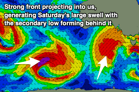 A temporary drop in size is likely Friday morning as we fall in between fronts, but we'll see the strongest of the progression this week projecting a fetch of gale to severe-gale SW winds right up and into us through the day, producing a large, late increase in SW groundswell that's expected to peak Saturday.
Size wise we're likely to see Middleton coming in at 3-4ft+ in the morning, jumping late to 5-6ft and then peaking Saturday to 6-8ft. The Mid Coast looks to persist at 3ft, increasing to 3-4ft later and easing from a similar size Saturday.
Winds on Friday will be best early and out of the W/NW for protected spots down South, shifting strong W/SW later morning and into the afternoon. Saturday then looks poor with strong but easing SW winds.
Conditions will improve into Sunday morning as another approaching front swings winds back to the W/NW down South with large easing sets from 5-6ft or so, bumpy and to 2-3ft in the Mid Coast.
We've got a secondary, stronger and longer-period S/SW groundswell on the cards for Monday, produced by a very intense polar low forming south-west of WA on Friday. A tight fetch of storm-force W/SW tending SW winds will be projected through our southern swell window as the low arcs around the bottom of a high and then up into Tasmania.
The strength of the storm and its track will deliver a large, long-period S/SW groundswell which will arrive Monday and build rapidly to what at this stage looks to be the 8ft range across the South Coast, with small 1-2ft waves on the Mid. Winds look an issue with an onshore SW breeze likely most of the day, better Tuesday and early from the W/NW as the large swell eases. We'll have a closer look at this on Wednesday though.