Good W/SW swells for the weekend, onshores to move in next week

South Australian Forecast by Craig Brokensha (issued Friday 21st April)
Best Days: Saturday Mid Coast, Sunday both coasts, Monday both coasts, early Tuesday keen surfers South Coast
Recap
Another day of pumping waves down South yesterday with all day offshores and perfect conditions into the afternoon. The Mid Coast was a tiny and bumpy 1-1.5ft.
This morning the swell was smaller but clean again down South, with tiny clean waves on the Mid with a variable wind. A new W/SW groundswell is due to 2ft on the Mid Coast this afternoon, and Cape du Couedic is picking up this energy, while the Southport cam is showing some better size to 1-1.5ft.
This weekend and next week (Apr 22 – 28)
This afternoon's increase in W/SW swell is due to peak overnight, easing back to 1-2ft on the Mid Coast tomorrow morning with 2-3ft sets off Middleton.
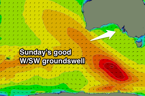
Into the mid-late afternoon the next pulse of W/SW groundswell should fill in, followed by the largest increase Sunday.
These swells have been generated by back to back mid-latitude frontal systems firing up towards the southern WA coastline, generating gale to severe-gale W/SW winds. The second system moved over the active sea state created by the first, producing the largest increase Sunday.
 Saturday afternoon's pulse should see consistent waves to 2ft on the Mid Coast again, with a bit more size off Middleton.
Sunday's swell should arrive during the morning and be well and truly in by late morning/midday with 2ft to possibly 3ft sets on the favourable parts of the tide across the Mid, while Middleton should build to 3-4ft.
Winds tomorrow are looking a little dicey down South with a light to moderate S/SE'ly, but the Mid Coast should be clean with a morning SE breeze, S/SE into the afternoon. Sunday should be a bit better down South with an E/NE offshore, favouring protected points and beaches before sea breezes kick back in.
Monday is the pick for the South Coast though with N/NE offshore, tending N/NW and then variable into the afternoon. Sunday's swell will ease, with 3ft sets expected off Middleton and easing 1-2ft sets on the Mid Coast.
A low point in swell is expected Tuesday morning and conditions should be clean early with a light variable wind, but a gusty S/SW change is due late morning as a cold front pushes up and towards us.
This front will bring with it an increase in mid-period S/SW swell, with some better S/SW groundswell also in the mix, generated by a strong polar frontal progression passing under the country through the weekend and early next week.
Unfortunately a slow moving ridge of high pressure moving in from the west will see onshore S/SE winds through Wednesday, more S/SW Thursday as the S/SW energy peaks. The Mid Coast isn't due to see any size due to the southerly direction and where it was created.
Longer term onshore winds look to persist through next weekend, but more on this Monday. Have a great weekend!