Great tomorrow morning, fun Mid swells from Friday afternoon

South Australian Forecast by Craig Brokensha (issued Wednesday 19th April)
Best Days: Both coasts Thursday morning, Friday morning South Coast, Friday afternoon Mid Coast, South Coast Saturday morning, Mid Coast Saturday afternoon, Sunday both coasts
Recap
Tiny surf on the Mid yesterday morning ahead of a new W/SW swell into the afternoon, providing good 2ft sets at swell magnets. The South Coast was clean and fun, with workable conditions into the afternoon as well as the swell built.
A larger SW groundswell filled in this morning across the state, but the Mid remained around 1-2ft, under the expected peak of 2-3ft. The South Coast saw solid waves around town, a touch wind affected with a fresh NE breeze. Selected spots were firing though for experienced surfers.
This week and weekend (Apr 20 – 23)
Today's large and powerful SW groundswell has already start to ease on the Cape du Couedic wave buoy and with this we'll see the swell easing later this afternoon and further tomorrow.
The Middleton stretch should ease from 3-5ft, with 1-2ft waves on the Mid Coast and an early N/NW offshore wind is expected to tend variable late morning ahead of a shallow SW change.
Friday morning will be smaller and winds look as if they'll be light but lingering from the S/SE across the South Coast. Keep an eye on the Hindmarsh Island observations for an indication on whether it's worth a drive for a surf.
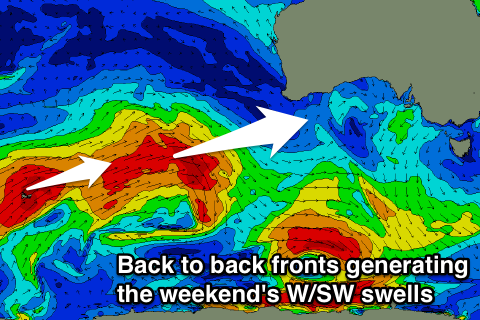 Into the afternoon, our new W/SW groundswell is expected to fill in, generated by a strong mid-latitude front pushing up towards the South-West of WA the last couple of days.
This swell will be best for the Mid Coast, kicking to 2ft through the afternoon as winds hold from the S/SE. The South Coast should increase to 3ft+ off Middleton but S/SE sea breezes will create average conditions.
Friday's swell is expected to drop back into Saturday with E/NE-NE breezes down South and offshores on the Mid.
Into the afternoon another good pulse of W/SW groundswell is due, followed by a stronger increase Sunday.
These two swells will be generated by back to back mid-latitude fronts projecting towards WA through our western swell window, with the secondary front being strongest and continuing to generate severe-gale W/SW winds in our swell window as it dips south-east under the country.
The first swell for Saturday afternoon should see sets kicking back to 2ft on the Mid Coast, with the South Coast hovering around 2-3ft off Middleton, while the stronger swell for Sunday providing 2ft to possibly 3ft sets on the favourable parts of the tide on the Mid, with bigger 3-4ft sets developing off Middleton.
Morning offshore winds will create great conditions but a surface trough will bring a S/SE change into the afternoon.
Early next week isn't looking to great down South with easing surf and onshore S/SE winds from Monday through Wednesday. The Mid looks fun with easing 1-2ft waves Monday, tiny into Tuesday and Wednesday.
Longer term strong polar frontal activity looks to generate good swells from mid-week but winds look as if they'll continue to be a bit of a problem. More on this Friday.