Great forecast period with offshore winds and strong swells

South Australian Forecast by Craig Brokensha (issued Friday 14th April)
Best Days: Both coasts, Sunday and Monday, South Coast Tuesday morning, Mid Coast into the afternoon, both coasts Wednesday and Thursday
Recap
A bit less swell across the South Coast yesterday morning but conditions were great again with a light morning offshore wind. The Mid Coast saw tiny 1ft waves continuing, ideal for beginners.
This morning a low point in swell was seen across both coasts with tiny 0.5ft peelers on the Mid and 1-2ft waves off Middleton.
A good new W/SW groundswell has already started to kick on the Mid Coast though with bumpy 1-2ft sets, and the Cape du Couedic buoy is on a steady climb.
We should see consistent 2ft waves through the afternoon and a late swing back to offshore winds.
This weekend and next week (Apr 15 – 21)
This afternoon's good pulse of W/SW groundswell is the first of two swells due today and tomorrow, with the biggest increase due to fill in overnight and peak tomorrow morning.
This has been generated by a good fetch of W/SW gales projecting towards us the last couple of days.
The swell provided large surf in WA yesterday and this morning, with good consistent 2ft sets due tomorrow across the Mid (likely the odd bigger one on the favourable parts of the tide) while the South Coast should see surf around 4ft off Middleton.
Conditions will be great across both coasts with an E/NE offshore on the Mid and N/NE tending N/NW breeze. Afternoon sea breezes only look weak so we should see good conditions for most of the day as the swell starts to ease.
Sunday morning will be smaller ahead of our new long-period SW groundswell through the afternoon.
This swell has been generated by a vigorous polar low south-west of WA, with core wind speeds reaching the storm-force range.
We should see an inconsistent but good kick in size Sunday afternoon, reaching 3-5ft across Middleton and 1-2ft on the Mid Coast.
Winds are looking a little suspect with a weak SW breeze possible at dawn but this will tend variable for the morning surf, so maybe wait until mid-morning for a paddle as the new swell starts kicking.
 Monday should be a touch smaller, but a weak polar front moving through our swell window over the coming days will produce a reinforcing W/SW swell, keeping Middleton up around 3-4ft with 1ft to occasionally 2ft waves on the Mid. Conditions will be excellent down South with a moderate to fresh N/NE wind, tending variable into the afternoon.
Tuesday morning looks to be another low point in swell (not small though) with a light morning offshore.
Into the afternoon a new strong W/SW groundswell should start showing, produced by a vigorous polar frontal progression forming this evening.
What we'll see is a gale to severe-gale fetch of pre-frontal W/NW winds projected through our western swell window, generating a moderate to large sized W/SW groundswell for Tuesday afternoon. Middleton should build strongly to 3-5ft by dark with 2ft sets on the Mid Coast.
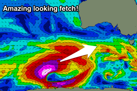
Of greater importance is the core of the polar low, generating storm-force W/SW winds over an active sea state and more in our south-west swell window.
This will produce a large long-period SW groundswell for Wednesday peaking through the morning to an easy 6ft off Middleton and 2-3ft on the favourable parts of the tide across the Mid Coast.
Conditions are looking excellent for both coasts with moderate to fresh N/NE breezes, similar Thursday as the swell eases.
Longer term we may see some fun new W/SW swell next weekend, but we'll look at this in more detail on Monday. Have a great weekend!
Comments
Mid Coast looking incredibly tasty this morning.