Good swell over the weekend, cleaner next week

South Australian Forecast by Craig Brokensha (issued Friday 24th February)
Best Days: Mid Coast Saturday keen surfers both coasts Sunday morning, South Coast Monday, Tuesday and Wednesday mornings
Recap
Improving waves on the Mid Coast yesterday with easing 2-3ft sets and easing onshore winds, creating decent conditions into the late afternoon and evening. The South Coast was small to tiny and onshore.
Today the Mid Coast was cleaner and around 1-2ft, while the South Coast remained small and onshore. A new swell should keep similar sized sets hitting the Mid this afternoon as Middleton builds towards 3ft.
This weekend (Feb 25 – 26)
This afternoon, the first pulse of SW groundswell will fill in across both coasts, and this is already building on the Cape du Couedic wave buoy.
The best pulse of SW groundswell for tomorrow is still on track, with a great fetch of W/SW gales moving under the Bight yesterday, on top of the active sea state generated by the storm responsible for this afternoon's swell.
Better 3-4ft sets should be seen across Middleton tomorrow, with 1-2ft waves continuing on the Mid, ahead of a drop in size Sunday from 3ft and 1-1.5ft respectively. Again, our models are over-forecasting the size for Sunday, incorrectly combining the easing S/SW swell and some S'ly windswell.
Winds will be best for the Mid Coast tomorrow with a SE tending S/SE breeze, while Sunday should become cleaner down South with a light E'ly (possibly E/NE for a couple of hours) but still lumpy and peaky before sea breezes kick in.
Next week onwards (Feb 27 onwards)
 Much cleaner conditions are due into Monday down South with a light N/NE offshore, but the swell will be small and easing from 2ft+ at Middleton. Waits and Parsons are the go for easing 3ft to nearly 4ft sets early.
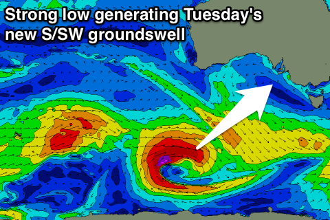
A low point is due early Tuesday morning, but a good new S/SW groundswell is due to arrive through the mid-morning, produced by a tight polar low over the coming days.
This low will track east-southeast from the Southern Indian Ocean, generating a good fetch of gale to severe-gale W/SW winds.
The swell should kick to a good 3ft at Middleton through the day Tuesday, easing from 2ft to occasionally 3ft Wednesday morning.
The Mid Coast will be tiny to flat.
Conditions should be good both Tuesday and Wednesday morning's with light NE-N/NE offshores before afternoon sea breezes kick in.
Longer term there's nothing too major on the cards and poor onshore S/SE winds are due to kick in from Friday next week, but more on this Monday. Have a great weekend!