Average week, best Friday and Saturday

South Australian Forecast by Craig Brokensha (issued Monday 2nd January)
Sign up to Swellnet’s newsletter and receive the South Australian Forecaster Notes and latest news sent directly to your inbox. Upon signup you'll also enter the draw to win a surf trip to P-Pass for you and a mate. It doesn’t get much easier so click HERE to sign up now.
Best Days: Friday and Saturday mornings South Coast swell magnets, Mid Coast Sunday
Recap
Tiny waves Saturday down South with less than ideal conditions and leftover 1-2ft sets on the Mid Coast.
Sunday was better down South with a new inconsistent swell although with a moderate onshore wind, while the Mid Coast dropped back to a tiny 0.5ft.
Today the swell was smaller along with a fresh onshore S/SE breeze down South and tiny waves on the Mid.
This week and weekend (Jan 3 - 8)
As touched on last Friday, this coming week will be poor regarding surfing options.
A slow moving high will direct persistent SE-S/SE winds across the South Coast until Friday, along with small amounts of groundswell.
Most of the week, S/SE windswell will be the dominant source of surf across the South Coast, with a small SW groundswell in the mix later tomorrow and more so Wednesday morning.
 A SE-E/SE breeze tomorrow morning will create poor conditions, similar into Wednesday but possibly more E'ly before S/SE sea breezes kick in. Parsons will offer the best waves with peaky 3-4ft sets, smaller into Thursday as winds go back to the S/SE.
Friday morning should reveal a better N/NE offshore through the morning but no major groundswell, with a small easing S/SE windswell to 2-3ft at most locations.
The Mid Coast is due to be tiny to flat all week.
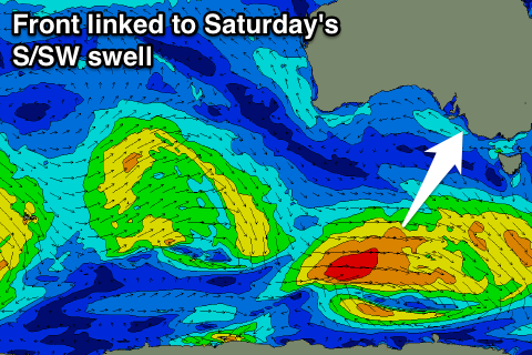
Later Friday and more so Saturday morning a new S/SW groundswell is due.
Friday afternoon's increase will be generated by a pre-frontal fetch of NW gales, with Saturday's pulse produced by a better aligned post-frontal fetch of W/SW gales more through our southern swell window.
Only a small swell is due, with Middleton coming in at 2ft, with 3ft sets at Waits and Parsons (tiny on the Mid) with an offshore N/NW wind. A late SW change us expected, but possibly not until late.
On Sunday the Mid Coast should see a good W/SW groundswell, produced by a strong mid-latitude low forming off the South-West of WA, pushing through the Bight while weakening. The size at this stage looks to be around 2ft+, but more on this Wednesday.
Longer term some better groundswell is on the cards for next week, generated by a strong polar frontal progression developing under us, but more on this Wednesday.