Good weekend for the South Coast, large W/SW swell for Monday but with onshores

South Australian Forecast by Craig Brokensha (issued Friday 29th July June)
Best Days: South Coast all weekend and early Monday, Mid Coast later Sunday through Tuesday for keen surfers
Recap
Average bumpy surf easing back from 2ft across the Mid Coast yesterday afternoon, more lumpy into the afternoon and back from 1-2ft this morning.
The South Coast was solid and pretty clean with the Chiton and Middleton region the pick, while this morning the surf was a touch smaller but super clean and lined up with a light offshore wind.
This weekend and next week (Jul 30 – Aug 5)
The weekend is looking great for the South Coast with a mix of S/SW and long-range SW groundswell due tomorrow, along with a late increase in new W/SW groundswell Sunday.
Tomorrow's mix of swells are being over-forecast by our models, with it incorrectly combining them, and we're instead looking at good clean fun 3ft to occasionally 4ft sets across Middleton with larger waves out at Waits and Parsons. The Mid will only likely come in around the 1ft range.
Conditions are good but will get a bit winy tomorrow with a moderate to fresh N'ly tending stronger N/NW breeze into the afternoon.
Come Sunday morning the swell should be easing and offshore NW winds are due all day, increasing through the afternoon more from the N/NW.
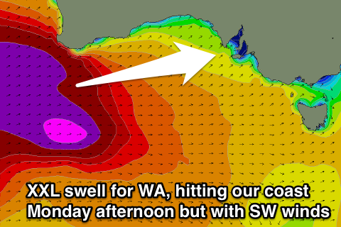 Through the mid-late afternoon though a strong new W/SW groundswell is due to fill in. Currently a strengthening mid-latitude front is projecting a fetch of W/SW gales towards WA, through our western swell window, with this front dipping under WA and pushing through the Bight tomorrow.
A moderate to large W/SW groundswell is due from this system, building strongly Sunday afternoon and reaching 2-3ft by dark on the Mid and 3ft to possibly 4ft across the Middleton stretch. With those N/NW winds the Mid will be bumpy but likely workable if we're lucky.
Into Monday the largest of the W/SW groundswells is due to fill in, generated by a secondary stronger mid-latitude front projecting a fetch of severe-gale to storm-force W'ly winds over the active sea state generated by the initial front, towards WA and then through the Bight again while weakening.
An XXL swell will be generated for WA, coming in XL across our West Coast and large once it hits Adelaide.
The Mid Coast is expected to build to a strong and powerful 3-4ft of pure groundswell into the afternoon, with the South Coast kicking late to 6ft on the sets across Middleton, larger at Waits and Parsons but smaller inside Chtion due to the westerly swell direction.
Conditions early Monday will be clean down South with a W/NW offshore, but a SW change is due through the day, and this will create average conditions as the large new W/SW groundswell fills in.
Tuesday looks to remain poor as well with fresh S/SW winds, owing to a developing and stalling low in the Tasmanian region. The Mid Coast may see an early S'ly breeze with easing 3ft sets, but we'll have to have another look at this Monday. Have a great weekend!