Great Tuesday, smaller windows into the end of the week, fun weekend

South Australian Forecast (issued Monday 3rd August)
Best Days: Tuesday South Coast, early Thursday South Coast, Friday onwards South Coast
Recap
Onshore average waves to start the weekend, but conditions improved into the afternoon as winds tended variable and the swell started to kick.
Sunday morning was great down South with a large SW groundswell and morning offshore winds that held from the W all day, favouring protected locations. The Mid was bumpy and around 1-1.5ft and not too appealing.
Today a large stormy swell was impacting the South Coast with choppy 2ft+ sets on the Mid with poor onshore winds.
This week (Aug 4 - 7)
 Tomorrow looks excellent down South with today's large building S/SW groundswell due to ease through the day but still be very solid early, under W/NW-NW winds. A late shift to the W/SW may be seen, creating bumpy conditions.
This will favour Middleton Bay and the Chiton Rocks region with easing 5-6ft sets at Middleton and 6-8ft waves at Waits and Parsons and bumpy 1-2ft waves on the Mid.
Come Wednesday the swell will continue to ease, but a fresh SW change is due around dawn, with only a slim chance of an early W'ly around Victor.
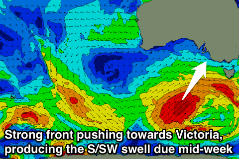
This onshore change will be related to the last of the strong polar frontal systems pushing up towards us under the influence of the Long Wave Trough.
This front will slightly escape the swell it's producing, but this should still generate a large S/SW groundswell pulse, building later Wednesday, peaking overnight and easing Wednesday.
Middleton should build and then ease from the 4-6ft range with 6-8ft sets at Waits and Parsons and 1-1.5ft waves on the Mid.
Winds will unfortunately remain generally onshore from the SW Thursday, but an early W'ly is likely around the Victor region. Friday will see the swell continuing to ease with more variable winds across both coasts.
This weekend onwards (Aug 8 onwards)
The weekend is looking fun across the South Coast, as the S/SW swell through the end of the week continues to ease, slowed by a couple of smaller reinforcing SW groundswell pulses.
Exposed breaks will come into play, with a dropping swell from 3ft+ at Middleton Saturday morning with 4ft sets at Waits under N/NE tending variable winds, and then smaller easing waves with N/NE winds Sunday.
Longer term a mix of short-range W/SW swell and long-range SW groundswell are due into Monday/Tuesday with some better energy into the end of the week, but we'll look at this again Wednesday.