Large swells to come but with tricky winds

South Australian Forecast (issued Friday 31st July)
Best Days: Saturday afternoon both coasts, Sunday morning South Coast, protected spots down South Monday, early Tuesday both coasts, early Wednesday South Coast
Recap
Another great day of surf down South, although a bit blowy with a strong S/SW groundswell coming in at 3-4ft+ across Middleton with Waits and Parsons on the too big side. The Mid was tiny and bumpy.
Today a reinforcing SW swells has kept 3ft+ sets hitting Middleton with larger waves at Waits and Parsons under offshore winds. The Mid was also clean but tiny and to 0.5-1ft.
 This weekend and next week (Aug 1-7)
Tomorrow morning is still looking poor across both coasts as we see the swell bottoms out with a strong but easing onshore S/SW change.
The afternoon should be better as winds tend more variable and a strong new SW groundswell fills in, building to 4-5ft at Middleton and 6ft+ at Waits and Parsons later in the day, with the Mid kicking to 1ft to possibly 2ft.
Sunday morning should offer similar sized waves, easing through the day ahead of a late new pulse of larger SW groundswell. Winds look to be from the W/NW through the morning, tending more W'ly to W/SW through the day
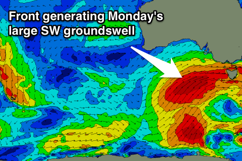
This will be generated by a secondary fetch of SW gales being projected up and towards us, on the back of the active sea state produce by the first front. Following this a fetch fetch of SW gales will be aimed at us into Sunday, generating a large and powerful SW groundswell for Monday.
But coming back to Sunday, and late in the day we should see Middleton building more to the 6ft range with 8ft sets at Waits and 2ft on the Mid.
Monday's larger pulse should build to the 8ft+ range through the afternoon across Middleton, with 10ft sets at Waits and Parsons, and 8-10ft waves across exposed offshore reefs.
The Mid should see 2ft to occasionally 3ft sets at the swells peak through Monday afternoon and then ease back from 2ft Tuesday.
Winds dawn Monday may be W'ly early down South, but a shift to the SW is due through the morning, persisting into the afternoon.
As the swell eases Tuesday early W/NW winds are more than likely around Victor with good options around the Chiton rocks region, while variable winds might be seen early on the Mid, increasing from the W/SW through the day.
A low point in swell is due Wednesday morning, while another couple of strong frontal system is forecast up push up and into us through the day.
This will bring an onshore change and building S/SW groundswell that's due to peak Thursday in the 5-6ft range across Middleton with 8ft sets at Waits and building to a messy 2-3ft on the Mid Wednesday, easing from the 2ft+ Thursday.
Unfortunately winds look poor Thursday and fresh but easing from the S/SW with better offshores Friday. More on this Monday though. Have a great weekend!