Lots of swell to come, larger from the weekend

South Australian Forecast (issued Monday 27th July)
Best Days: South Coast from tomorrow through the weekend
Recap
Onshore 2-3ft waves across the Mid Saturday with cleaner options down South with a fun size swell best suited to Middleton.
Sunday was a semi-stormy but easing 3ft on the Mid while the South Coast offered plenty of size with early W'ly winds, but they shifted onshore pretty quickly through the morning.
Today conditions were better across both coasts with a secondary pulse of large S/SW groundswell down South to 6ft+ with offshore winds, while the Mid was a bumpy but workable 2ft.
This week (Jul 28 - 31)
This morning's large S/SW groundswell pulse down South will ease this afternoon and further tomorrow, bottoming out Wednesday morning.
Conditions will be good tomorrow with an light to moderate offshore NW'ly down South, persisting most of the day if not tending W/NW at times, while the Mid should see more variable breezes, but a tiny easing 1ft+ of swell.
Come Wednesday afternoon, a mix of strong new SW groundswells are due, generated by a strong polar frontal progression that's developed along the polar shelf the last couple of days, with currently a fetch of severe-gale W'ly winds being generated in our south-western swell window.
The swell should build strongly through the mid-late afternoon, reaching 3-4ft at Middleton and 5ft at Waits and Parsons with 1ft sets on the Mid, peaking overnight and then easing Thursday from 3-5ft at Middleton and 5-6ft+ at Waits and Parsons under N/NW winds. The Mid should have 1-1.5ft sets but with average conditions.
Friday will be smaller with W/NW winds.
 This weekend onwards (Aug 1 onwards)
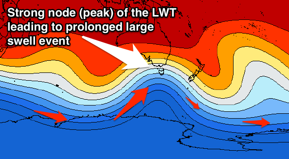
As touched on last update, we've got a larger SW groundswell on the cards for this weekend/early next week, in fact three, all due to a strengthening node of the Long Wave Trough pushing in from the west.
This will direct a series of vigorous polar fronts up towards us through the end of the week and weekend, with three successive fetches of severe-gale SW winds due to be aimed through our swell window, tending more southerly each time.
An initial large pulse of SW groundswell is due to build through Saturday and peak overnight, but still be large Sunday morning, with a late kick in secondary S/SW groundswell due ahead of a third large S/SW pulse later Monday/Tuesday.
Each pulse looks to peak around 6ft at Middleton with larger sets in the 8ft range at Waits, while the Mid won't see much size above 2ft (more so from the first pulse). Winds are a little dicey at this stage with an early W/NW'ly down South Saturday morning ahead of an onshore change and then light NE winds Sunday before SW winds kick in again Monday. We'll have a closer look at this Wednesday though.