Great Thursday, stormy weekend

South Australian Forecast (issued Wednesday 22nd July)
Best Days: Thursday both coasts, Saturday morning South Coast, Sunday Mid Coast for stormy waves, Mid Coast Monday morning, Tuesday South Coast
Recap
Small to tiny surf down South yesterday, only really surfable at Waits and Parsons but with fresh to strong offshore winds. The Mid Coast was tiny and junky early, but a NW windswell build to a messy 2ft through the afternoon along with strong N'ly winds.
Today the NW windswell eased back across the Mid, but a new W/SW swell should built this afternoon to 2ft on the sets, while the South Coast was small, clean and on a slow building trend.
This week (Jul 23 - 24)
Tomorrow looks great across both coasts, with this afternoon's building W/SW swell due to peak during the morning and then ease into the afternoon and further Friday.
The Mid should ease from 2ft with winds expected to hold from the NE all day.
The South Coast should drop from 3ft+ at Middleton and 4-5ft at Waits and Parsons early under N/NE winds.
Friday will be clean and best in protected locations across the South Coast with a fresh to strong NW tending W'ly wind, while the Mid should see an afternoon increase in windswell to 2ft.
This weekend onwards (Jul 25 onwards)
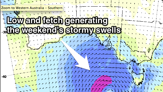 A strong and powerful frontal system is expected to push east across us through the weekend, with a building semi-stormy windswell due across the Mid Saturday, reaching 2-3ft into the afternoon, with a larger stormy but easing windswell Sunday from 3ft+.
The South Coast will see small to moderate amounts of W/SW swell Saturday coming in around 3ft on the sets across Middleton, with more size to 4-5ft at Waits and Parsons.
Strong and strengthening NW winds are due most of the day, so again protected spots down South will be the go.
Come Sunday the frontal system will push east and across us, with strong onshore SW winds down South (slim chance W'ly at dawn around Victor) with large building levels of SW swell.
This will be due to a fetch of SW gales being aimed into the South Coast, kicking Middleton to the 6ft range during the afternoon with 8ft sets at Waits and Parsons.
Monday will unfortunately remain onshore with S/SW tending S/SE winds with solid levels of easing S/SW swell across the South Coast. The Mid Coast should be cleaner with S'ly winds and an easing swell from the 2ft range through the morning.
Longer term, a small pulse of SW groundswell is due Wednesday afternoon ahead of a larger pulse of long-period SW groundswell Thursday, generated by a strong but distant polar frontal progression firing up in the Heard Island region Saturday, pushing east closer to us through early next week.
A moderate to large sized SW groundswell is on the cards at this stage with likely northery winds, but we'll have a closer look at this on Friday.