Average week ahead, better weekend

South Australian Forecast (issued Monday 13th July)
Best Days: Early Tuesday, possibly Wednesday morning down South, Wednesday morning on Mid, Saturday and Sunday South Coast
Recap
Average 3ft waves across the Mid Coast Saturday, building into the afternoon and becoming more stormy as winds increased. Sunday morning offered stormy 3-4ft waves, with strong but easing onshore winds, with the swell backing off to a junky and average 2ft this morning.
The South Coast was fun and good in protected locations Saturday with the mix of building swells, while the strong onshore change created large stormy conditions yesterday. The surf has improved into this morning though with winds swinging back to the west temporarily with an easing mix of swells. Winds have since gone back onshore creating average conditions.
This week and weekend (Jul 14 – Jul 19)
 This week isn't looking too flash, with plenty of swell due to impact the state, more so the South Coast, but with average winds.
Early tomorrow morning is likely to be the only window for clean conditions across the South Coast, with an early and fresh W/NW'ly ahead of a strong SW change mid-late morning.
Middleton should offer good 3-4ft sets with a new SW groundswell, with 5ft+ waves at Waits and Parsons, while the Mid is due to be in the 1-1.5ft range.
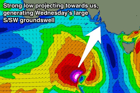
The strong onshore change will be related to a strong polar low pushing up and into us, with a fetch of severe-gale S/SW winds being projected straight into Kangaroo Island and the South Coast.
The South Coast should see easy 6ft surf across the Middleton stretch, with 8ft sets at Waits and Parsons and offshore reefs. The Mid Coast isn't expected to see any major size due to the swells direction with an average 2ft of swell due, easing quickly through the day.
Conditions are expected to be terrible Wednesday, BUT, one of the models has the low generating the swell pushing just west of us resulting in variable breezes, before freshening from the SE. The other models have strong onshore S/SE tending SE winds, creating terrible conditions down South, but clean waves on the Mid.
With this in mind, keep an eye on the Hindmarsh Island wind observations through Tuesday evening and early Wednesday for a window to hit the South Coast.
Into the rest of the week, fresh S/SE winds will create poor conditions Thursday with an easing S/SW swell, while Friday should see weaker, but still moderate S'ly winds.
Two pulses of long-period and good sized SW groundswell is due into Friday/Saturday slowly into the afternoon and further Sunday, generated by a broad and elongated fetch of pre-frontal W/NW gales currently south-west of WA near the polar shelf.
This swell will be inconsistent but strong, offering inconsistent 3-4ft waves at Middleton, with 5-6ft sets at Waits and Parsons from Friday through Saturday morning, easing into the afternoon. The Mid won't see any size with tiny 0.5-1ft sets.
Winds should improve and tend light NE Saturday morning, creating improving conditions down South, but the surf will still be very wobbly/lumpy.
Sunday is the day to surf, with exposed breaks down South the pick under N/NE tending NE winds.
Longer term we've got some solid W/SW groundswell on the cards for the middle of next week, as a vigorous frontal progression pushes in from Western Australia. More on this Wednesday though.
Comments
Hey Craig,
Was just wondering how Yorkes is lining up for Thursday - Saturday?
Pondie or Salmon Hole?
Thanks!!!
?
Craig's been away since Monday afternoon. However we don't give out location specific forecasts Tyson.
Fair enough
Thursday through Friday you'll be seeking protected breaks with that S/SE and the S'ly breeze, but the swell direction isn't great for these spots.
Funky winds Saturday with a dying swell and then by the time winds go N'ly Sunday, there won't be too many options. Not the best period.