Great weekend across the South Coast

South Australian Forecast (issued Friday 3rd July)
Best Days: Saturday, Sunday and Monday morning down South, Wednesday through Friday down South, Mid Thursday afternoon and early Friday
Recap
Poor onshore winds and a building swell yesterday down South with tiny waves on the Mid which kicked a little into the afternoon and improved with easing S'ly winds.
Today the surf improved drastically as winds swung offshore and the swell remained strong to 3-5ft across the Middleton stretch, while Waits and Parsons were too big. The Mid was clean and offering fun easing 1ft to occasionally 2ft sets.
This weekend and next week (Jul 4 – Jul 10)
 The weekend's looking excellent across the South Coast, as well as most of next week, besides Tuesday.
Today's mix of S'ly swells will ease back noticeably overnight, with Middleton due to ease from 3ft+ with 5ft sets at Waits and Parsons and tiny 1ft waves on the Mid.
Winds are looking great with a persistent N/NW'ly (N/NE on the Mid through the morning).
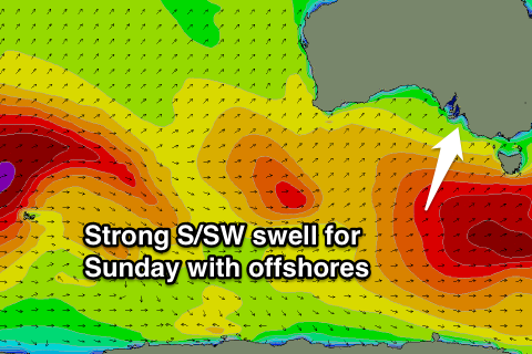
Sunday's strong S/SW groundswell is still on track, with the strong polar low linked to this swell, currently south-southwest of the state, projecting a fetch of W/SW gales up towards Tasmania.
A strong S/SW groundswell will result, peaking through Sunday to 4-5ft across Middleton. With 6ft+ sets at Waits and Parsons and 1ft waves on the Mid. Conditions should be excellent with a fresh N/NW tending NW breeze.
A drop in size is due into Monday and protected locations will be best with a fresh W/NW'ly ahead of a SW change mid-late afternoon.
The weak surface trough responsible for this change should kick up a small W/SW swell to 1-2ft across the Mid through the day, easing back into Tuesday.
Winds are still looking dicey early Tuesday with a SW'ly across both coasts, but this will ease and tend variable through the day. Victor may even see an early W'ly, but we'll review this Monday.
Wednesday will be clean again and best at exposed beaches on the South Coast with a N'ly tending variable breeze.
Into the second half of the week some inconsistent and small to moderate pulses of long-range W/SW groundswell are due across the state, generated by a couple of strong polar frontal systems currently moving through the Indian Ocean, in our far swell window.
An initial very inconsistent W/SW groundswell pulse due to build through Thursday won't offer any major size, with Middleton due to build to 2-3ft with 4ft+ sets at Waits and Parsons, while the Mid should see 1-1.5ft sets into the afternoon.
A slightly better pulse is due Friday as the frontal progression pushes closer to us and under WA early next week, keeping 2-3ft waves hitting Middleton, with 4-5ft sets at Waits and Parsons and 1-1.5ft waves on the Mid.
Winds should remain favourable and offshore from the N/NE Thursday and then N/NW Friday. More on this Monday though, have a great weekend!