Great waves to come

South Australian Forecast (issued Monday 1st June)
Best Days: Tuesday, Wednesday, early Thursday exposed spots, Friday onwards down South
Recap
Pumping surf on Saturday down South with a large SW groundswell and offshore winds for protected locations. Sunday was smaller but still good in protected locations with a morning W/NW tending W-W/SW breeze. The Mid Coast had bumpy 2ft sets all weekend.
Today a final pulse of large S/SW groundswell has filled in across the South Coast providing 6-8ft bombs with lumpy conditions under a lighter N/NE wind. The Mid Coast was clean also but only around the tiny 1ft range with the southerly direction.
This week (Jun 1 – Jun 5)
The coming few days are looking excellent with today's large S/SW groundswell due to ease away steadily under offshore winds.
Middleton should ease back from 4-5ft with bigger 6ft bombs at Waits and Parsons under a light to moderate N/NE offshores that will swing more E/NE into the afternoon. Wednesday should be great all day with fresh N/NE tending N'ly winds with easing 3ft sets at Middleton and 3-4ft waves at Waits and Parsons.
Thursday should remain clean but the swell will be small and only surfable at exposed beaches with a fresh N/NW tending lighter W/NW breeze ahead of an afternoon SW change.
This change will be linked to a small but intense mid-latitude low pushing in through the Bight on Wednesday evening and Thursday, bringing with it a small spike in swell for Friday across both coasts.
 No major size is expected with the Mid coming in at 1-1.5ft, while Middleton should see 2ft sets with 3ft waves at Waits and Parsons.
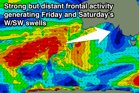
A better but inconsistent W/SW groundswell is due through the day though, generated by a flurry of vigorous frontal activity in the southern Indian Ocean over the coming days, under the influence of the Long Wave Trough.
This should see the Mid offering better 2ft sets with Middleton building to 3ft on the sets with 3-5ft waves at Waits and Parsons under W/NW winds.
This weekend onwards (Jun 6 onwards)
Further swell activity is due from this weekend, into next week as a strong node of the Long Wave Trough moves in from the south-west of WA later this week and then across to us early next week.
Friday's initial swell should be backed up by a better and more consistent pulse Saturday coming in at 3-4ft across Middleton with 5ft sets at Waits and 2ft on the Mid.
A further couple of pulses are then due Monday and then Tuesday/Wednesday next week, but we'll have a closer look at this on Wednesday. Winds generally look to hold from the NW, favouring the South Coast over the Mid.